

© Shipping Wonders of the World 2012-

The Suez Canal
A corridor between East and West, a vital link with the destiny of nations, and a short cut to India, the Suez Canal looms large in the story of the sea
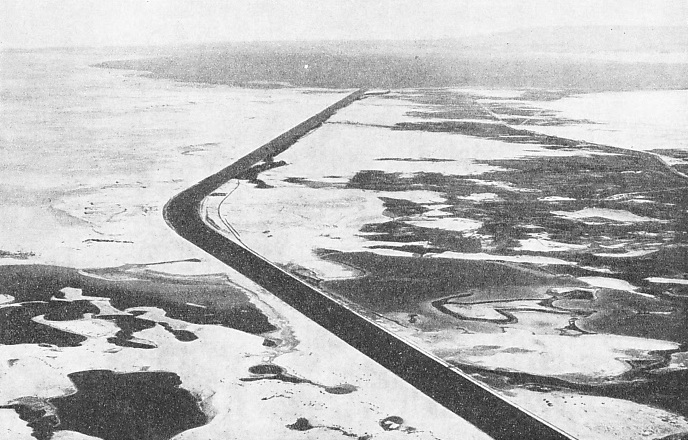
GREAT ENGINEERING TRIUMPH. The Suez Canal, illustrated here by a remarkable infra-
ABOUT three-
The Suez Canal, one of the wonders of the world, has a total length of over a hundred land miles, or eighty-
Since the canal was opened on November 17, 1869, it has become the vital link in the chain of sea transport between Europe and the Far East. It connects the Mediterranean Sea with the Red Sea, Port Said being the Mediterranean terminal and Port Tewfik, near Suez, at the head of the Gulf of Suez, the southern terminal.
So important is the canal to the world that it is taken as the dividing line between East and West, and the phrase “East of Suez” is apt. The division is apparent to every traveller who makes the transit of the canal. On the one side is the cold efficiency of the
Occident, and on the other the colour, squalor, smells, subtlety, and heat of the Orient. Travelling from the West the traveller gazes on the scenes along the banks of the canal with never-
 Ferdinand de Lesseps was a great Frenchman who thought of many things, but it is doubtful if he ever realized that thousands of men would come to regard his canal as a line of demarcation in their lives. The present writer was much amused by the remark of a ship’s wireless officer who said that the statue to de Lesseps at the entrance to the canal at Port Said gave him the impression that de Lesseps’ outstretched hand was indicating the canal as though to say, “Alone I did it!” De Lesseps was too gentle and chivalrous to make such a claim as that; he made many things, but never a boast. At the base of the statue are the Latin words, Aperire Terrain Gentibus -
A PLAN OF THE CANAL which shows all its chief features. With a total length of over eighty nautical miles, about sixty miles are actual canal and over twenty miles pass through dredged channels in Lake Timsah and the Great and Small Bitter Lakes.
This short cut was for the ships of all nations. He saw that and he built it. De Lesseps was a genius and, as are most geniuses, was ahead of his time. Much has been written of the obstinacy of his opponents, but it must be remembered that de Lesseps always looked ahead, whereas his adversaries thought chiefly of the past and the present.
When the canal was opened to traffic the sailing ship was still queen of the ocean. The canal cut such large distances off the route to India and the Far East that a great impetus was given to the improvement of the steamship. Sailing vessels could not benefit by the Suez Canal; the winds of the Mediterranean are variable, and the Red Sea is not suitable for sailing ships. In addition, the world was railway-
This period was the heyday of the sailing ship. Far better vessels than the steamships of that time, they had behind them tradition, experience, and faith in the established order of things. The steamship was still an experiment. Fine ships set out from England, picked up the north-
Although the Suez Canal did not cut many miles off the route to Australia, it was obviously the short cut to India and the Far East -
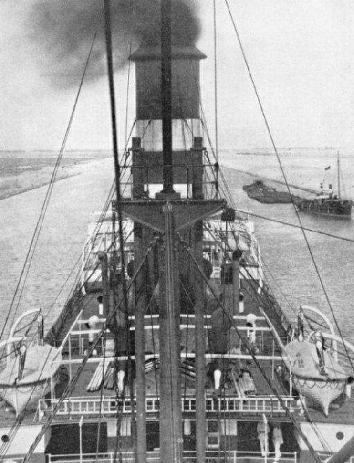
The Suez Canal, an international waterway. The maximum permitted speed of ships in the Suez Canal is seven and a half knots. The waterway is controlled by the Suez Canal Company and has been enlarged from time to time; the largest vessel to have used the Canal is the Empress of Britain, 42,348 tons. Vessels pass through at all hours, and a special searchlight, devised for navigation at night, illuminates both banks some distance ahead of the ship.
The waterway now operated by the Suez Canal Company is considerably deeper and wider than the original canal opened in 1869, as it has been improved from time to time to accommodate vessels as the size of ships increased. The largest vessel to have used the canal up to the time of writing is the Canadian Pacific liner Empress of Britain, 42,348 tons. Far-
There are no locks, bridges, or works to hamper the progress of ships. The length of the canal from the lighthouse at Port Said to the southern end of the quay at Port Tewfik is about 100 miles, of which nearly two miles run between the Port Said basins. The dredged channel in Port Said Roads is four miles long, and that at Suez over two miles so that the total length of the waterway maintained by the company is some 106 miles. The width at the bottom of the channel varies. At a depth of 32·9 feet the minimum width is 196 feet and some lengths are 328 feet wide. The surface width normally varies from 400 to 500 feet. The maximum permitted draught for vessels is 34 feet at the time of writing.
Coming from the Mediterranean a vessel has on her starboard side the West Breakwater dividing the channel from Lake Menzaleh; she steams through the dredged channel and draws level with the head of the East Breakwater. A little farther on is the impressive statue of de Lesseps; with right arm outstretched the figure indicates the entrance to the canal, “Here is my work!”
Next is the lighthouse from which all distances along the canal are measured, mile-
and supported the project financially, but did not live to see the completion of the great work. Said should be pronounced Sigh-
Transit of the Canal
Meanwhile the captain has been arranging with the authorities the details of the transit of the canal. After leaving the harbour, the ship steams south for about twenty-
Except for one short section, the canal is straight across Lake Menzaleh. The site of the channel being too shallow in places to permit dredgers to be used, local natives dug the earth, passing the clods from hand to hand to each bank, the clods being used to build up the embankments. When the channel was sufficiently deep, dredgers were floated in to remove the soil more quickly, the soil being cleared from the channel by means of a contrivance similar to a great iron spout. It was 230 feet long, 5½ feet wide, and 2 feet deep. The soil was dumped into it, converted into sludge by water, and then pumped clear of the channel.
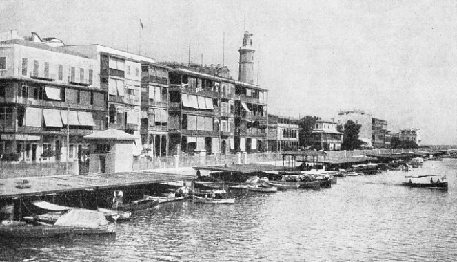
PORT SAID is at the northern entrance of the Canal. Liners berth at Port Said, which is on the west side of the entrance. This port, with 100,000 inhabitants, was named after Said Pasha who, as Viceroy of Egypt, backed de Lesseps with his influence and gave financial support to the great project. De Lesseps drove a pick-
From Kantara to Lake Timsah the ground is higher. The sill of the canal in this section is at El Guisr, where the canal banks are 49 feet above the water. As the canal was designed to follow the lowest part of this comparatively high ground several curves had to be made, one being to take advantage of the depression caused by the Balia lakes. After the curves through the high ground at El Guisr the canal enters Lake Timsah. The town of Ismailia, on the west side of the lake, a green oasis in the desert, is the half-
Leaving Lake Timsah, the vessel passes between high banks, and after proceeding for a number of miles the vessel enters the Great Bitter Lake, which is about ten nautical miles long and from two and a half to six miles wide, and steams through the dredged channel to the Little Bitter Lake, passing through another dredged channel. The sides of the canal are of sticky mud here, but in the next and last section from the end of the lake to Port Tewfik the canal is cut through hard, and in some places rocky, ground. Rocky places where vessels should not secure to the bank are marked by buoys and posts. The famous port of Suez is not on the canal, but lies off the west bank, and is reached by a creek. The southern terminal of the canal is Port Tewfik, and Port Ibrahim. The former is the official terminal of the canal, and Port Ibrahim, which adjoins, is controlled by the Egyptian Government. The district is linked with the port of Suez. On this last section there is another sill at Chalouf, between the Little Bitter Lake and Port Tewfik.
Navigation by Night
Once vessels could only pass at a few gares, or crossing stations, but now that the canal is wider ships can pass at almost any point. The rule is that one ship stops while the other proceeds. The maximum speed is seven and a half knots, which is quite a good speed for ships in confined waters. Formerly navigation ceased at night, but with increased traffic night navigation became imperative. A special searchlight was devised, known as a Suez Canal light, and arranged in the bows; navigation at night was authorized in 1887, so that ships pass through at all hours.
This searchlight consists of two divergent beams of light which illuminate either bank of the canal some distance ahead, with a dark sector in the middle. There are thus three sectors, each of five degrees. The two beams of light touch the banks of the canal 1,300 yards ahead. Except in the Bitter Lakes, at every six miles there is a fully staffed station which keeps in touch with all other stations by telephone and telegraph. Contact between every part of the canal is thus established, and track is kept of all ships throughout transit. Any accident to a ship or to the banks can be known to the authorities within a few seconds. Although it has been made in less time, the mean transit time is about thirteen hours and, accordingly, night navigation at some period is essential. Precedence is given to mail-
There is some current in the canal, according to the season. From November to April the set between Port Said and the Great Bitter Lake is northward, and from June to October southward, the maximum rate being seldom more than one knot. There is no tidal stream in Lake Timsah or the Great Bitter Lake. Between the Little Bitter Lake and Port Tewfik there is a tidal stream. The Mediterranean is, of course, almost tideless, but the Red Sea is tidal, and this accounts for the stream between Port Tewfik and the Little Bitter Lake, the water of which lake is, however, always at the same level. At a point some seven miles from Port Tewfik, the tidal stream attains its greatest rate of one and three-
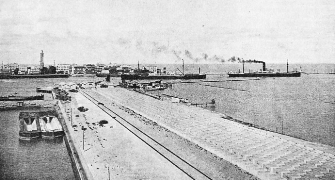
THE ENTRANCE TO THE HARBOUR at Port Said with Port Fuad in the foreground. Transit dues at the time of entry into the Canal are five gold francs per net Suez ton, ships in ballast paying only half this rate. For every passenger over twelve years of age taken through the Canal a charge of ten gold francs is made. In 1934, a representative year, the total number of transits was 5,663, amounting to a net tonnage of over 31,000,000. The Suez Canal Company’s engineering and repair shops are situated at Port Fuad.
The Suez Canal depends upon the Fresh Water Canal. This brings drinking water from the Nile across the desert, and, although it does not float the ships which pass through the maritime canal, is the life-
The company does not own the canal in perpetuity. The concession expires in 1968, after which the canal passes into the hands of the Egyptian Government, unless other arrangements are made. The company is registered as an Egyptian body with headquarters in Paris, and the canal was constructed by French engineers, with capital that was mainly French and partly Egyptian, by French and Egyptian labour. More than half the revenue is normally derived from British ships, the route being vital to the British Empire. Less than half the shares -
The president of the company is always a Frenchman. There are thirty-
All the executive work is done in Bgypt. The head officer, called the Chief Agent, has his offices in Cairo, and is the diplomatic officer in charge of relations with the Egyptian Government and is supreme, being directly responsible to the board in Paris. He supervises traffic, works, health, houses, buildings, legal business and water supplies.
The principal officers of the traffic department are recruited from the French Navy. Engineering work, workshops, ferries and tugs are controlled by the works department, of which the main secretariat and personnel is French, but the workers are cosmopolitan. No appointment is made without two years’ probation.
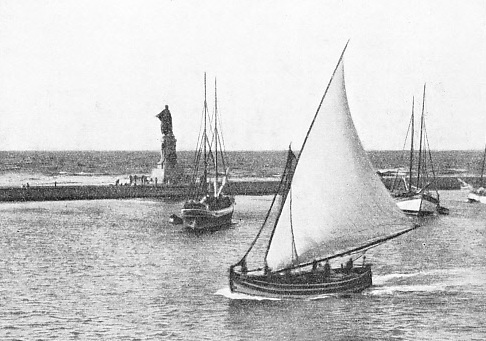
THE STATUE OF DE LESSEPS, the creator of the Canal, is at the entrance to the Canal at Port Said. At the base of the statue are Latin words signifying: “To Open the Earth to All Peoples”. The engineer was most persistent in his ambition to build the Canal and it is said he travelled a total of 70,000 miles trying to get his scheme accepted. He finally succeeded in winning the support of the French and Egyptian Governments.
The canal is of paramount importance to British shipping. Figures vary from year to year, those for 1935 being affected by the war in Abyssinia. Taking 1934 as a representative year, 3,071 transits of the canal were made by British ships, representing a net tonnage of 17,238,128. The total figures for all nations were 5,663 transits and 31,750,802 net tons. British figures were, therefore, more than half the totals. Germany occupied second place with 509 transits and 2,976,451 tons. The Italians were third in the number of transits, 435, but the tonnage, 2,089,003, was below the 2,559,182 of Holland, Dutch ships making 378 transits. French, Norwegian and Japanese ships came in the order named. The company prescribes movements of ships to ensure safety and the speedy passage of mail ships. Vessels carrying ammunition, explosives or other dangerous cargo have to conform to special regulations. Vessels are not allowed to overtake one another under way, and speed has to be eased when passing sidings, sections of the bank where work is being done, or dredgers and barges. The system of measurement is that established by an international commission.
When railways developed and steamships came into being, the world became interested in speed. The Isthmus of Suez was the obvious short cut in travel and communication, and the overland route across the isthmus attracted attention. Rather more than a century ago a certain British officer named Waghorn took some duplicate dispatches from London to Bombay and raced a ship which was carrying the originals to India round the Cape of Good Hope. Waghorn went by way of Alexandria and Suez, and then by sea. He died in penury later, but he stimulated the desire for speed, De Lesseps erected a monument to him at Port Tewfik, and the P. and O. line developed this overland route for mails. Later, the British obtained a concession for building a railway from Alexandria to Suez. It should be remembered that when de Lesseps started his propaganda for a ship canal, the P. and O. company were among his most ardent supporters.
The inauguration festivities were magnificent. A great fleet assembled at Port Said ready to make the first transit on November 17, 1869. Although British ships then formed the bulk of the traffic Britain had no shares in the canal. In November, 1875, Disraeli, the Prime Minister of England, heard that Ismail Pasha, in need of money, was trying to sell his shares in the canal to French interests. Disraeli called a meeting of the Cabinet, obtained their consent, raised £4,000,000 from Baron Rothschild, and in about nine days the Egyptian shares were in British hands. This achievement was the crowning point of Disraeli’s career.
Traffic in the canal has been interrupted only on two occasions, once for two days during Arabi Pasha’s rebellion in 1882, when British naval forces took over the canal temporarily, and once for less than a day during the Great War.
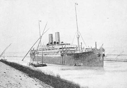
A PASSENGER LINER in the Suez Canal passing a native dhow. The special searchlight carried through the Canal is shown slung over the liner's bow. When two large ships pass one another in the Canal, one of them has to be “tied up” while the other goes slowly by.
You can read more on “The Corinth Canal”, “The Panama Canal” and “World Waterways” on this website.