

© Shipping Wonders of the World 2012-

The Congo: Central Africa’s Highway
The River Congo and its numerous tributaries form the only means of transport through thousands of miles of central Africa. Where navigation is obstructed by rapids and gorges, railways connect the navigable sections of the river
THE vast system of African waterways known as the River Congo drains an area approaching 1,500,000 square miles. The head-
The river is joined by great tributaries almost as long as itself, and flows into the South Atlantic after a course of some 3,000 miles. Continuous navigation is prevented by rapids, and only about 1,750 miles of the main stream are open to navigation by river steamers. About 9,000 miles of waterways, however, including the tributaries, are used by all manner of craft from dug-
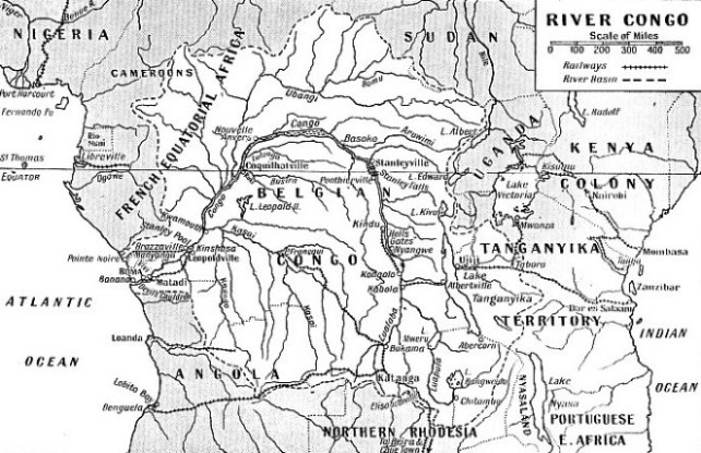
AN AREA OF 1,500,000 SQUARE MILES is drained by the waterways of the Congo. This area is shown on the map in white. In its upper reaches the Congo is known as the Lualaba. Railways between Matadi and Leopoldville, Stanleyville and Ponthierville, Kindu and Kongolo avoid cataracts and other obstacles to navigation, and thus connect the navigable sections of the river. Matadi is the limit for ocean-
The Congo is an extraordinary river. Its outlet to the sea is choked by a long succession of rapids which begin about ninety miles from the mouth. To reach Matadi, the limit of navigation for ocean ships, vessels have, at one season, to fight a current that reaches a velocity of 11 knots at a place called the Devil’s Cauldron. Steamships with a speed of 10 knots have been forced back at this point, where the current swirls round in whirlpools, and have had to wait until the strength of the stream has waned.
Above Matadi a railway takes passengers and goods to the ports on Stanley Pool, about 250 miles away. From Stanley Pool, where the Congo forms a lake fourteen miles wide and twenty miles long, there is an uninterrupted stretch of over 1,000 miles of navigation up the Congo itself, with other streams which afford routes into the interior and form the only highways into the jungle. These waterways are the arteries from the heart of Africa which unite above Stanley Pool and flow through the bottle-
It is estimated that there are about 4,000 islands in the River Congo, some of them up to fifty miles in length. In some places the river is several miles wide, in others it is penned between gorges. The shallow bed of sand shifts under the pressure of the water, and the channels change constantly. Islands of floating vegetation form a menace to small craft. These green “icebergs” will crush a boat as remorselessly as their brothers of the Arctic and Antarctic regions. Although the questing Portuguese discovered the mouth of the Congo a few years before Columbus reached the West Indies, the Congo was not mapped until comparatively recently. It is not fully known even yet, if we include the ramifications of its tributaries. Except for the river steamers and the trading stations — these stations are called “factories” in West Africa — civilization has not made great changes. The handful of Europeans who administer the territory now known as the Belgian Congo have found it difficult to number the people, who resent being the subject of a census. The territory of the Belgian Congo has an area of about 910,000 square miles, and the population in 1933 was said to be 9,383,900.
Two men opened up the river. One was a man educated in a British workhouse, Sir Henry Morton Stanley, and the other a European king, King Leopold II of Belgium. Both have been bitterly attacked; neither lacked intelligence or courage.
The first Europeans to enter the Congo from the sea were the Portuguese under Diego Cam, who sailed from the Portuguese settlement of El Mina (Gold Coast) in 1482 and ascended the Lower Congo. Cam put up a pillar at the southern entrance. The local people called the river the Congo or the Nzadi, As the nearest approach in Portuguese to Nzadi was pronounced as Zaire, these two names of Congo and Zaire were used.
Slaves were brought down the river. European ships collected them at Boma, fifty nautical miles from the sea on the right bank of the river, and this place enjoyed at one time the unenviable notoriety of being one of the chief slave markets of the world.
Stanley Meets Livingstone
In 1816 Captain Tuckey arrived at the mouth of the river. He had been sent by the British Government to test a theory that the Niger and the Congo were the same river. The British sent another expedition overland to the Niger, so that if Tuckey could join forces with this the mystery of the river would be solved. The men sent overland died and the same fate befell Tuckey. He went as far as the rapids and some of his sailors explored the mountains beyond them, but fever killed Tuckey and many of his men. The territory now known as the Belgian Congo has only a narrow strip of coast-
The large River Ubangi and its tributaries, which unite and flow into the Congo at a point below the Equator, form the boundary between French and Belgian soil. On the north-
The name of Stanley is indelibly associated with the story of the Congo. His practical experience of rivers and of the craft which operate on them helped him to open up the waterway. Stanley’s real name was John Rowlands. He was born in Denbigh, Wales, in 1841, and as a child he was taken to St. Asaph Union Workhouse. At the age of fifteen he and a companion ran away. After various adventures Stanley shipped as cabin boy at Liverpool in the packet Windermere, an American vessel. He sailed to New Orleans, and he was so ill treated in the ship that he found it wiser to go ashore.
Here he was befriended by an American, Henry Morton Stanley, who helped to find work for him. During the absence of this man the lad lost his employment, spent his savings and went by river steamer to St. Louis, where he found that his benefactor had just left for New Orleans. To get back the lad worked his passage in a flat-
Stanley stored up in his mind the lessons he had learnt on the Mississippi. He saw service as a soldier in the American Civil War, served later in the U.S. Navy, and then became a journalist. His roving disposition led him to Asia and Africa. His crowning achievement as a journalist was the finding of Dr. Livingstone, who had vanished in Central Africa. Stanley went to Zanzibar and then crossed East Africa and found Livingstone at Ujiji, on the eastern shore of Lake Tanganyika.
Livingstone did not wish to return to civilization as he had not finished his work of exploration. He had followed the course of the River Lualaba for some distance and he believed that this river, which becomes the Congo, was one of the head-
Assailed by Poisoned Arrows
He went to Zanzibar, recruited his native followers and travelled overland to Lake Victoria, Africa’s largest lake. Here he began his explorations by circumnavigating the lake in a sectional boat which he had brought from England. This was the craft which afterwards carried him down a great part of the Congo to a point near the sea. It was of cedar wood, 40 feet long with a beam of 6 feet.
After adventures in Uganda and on Lake Victoria, Stanley explored Lake Tanganyika in his boat, and then began his Congo adventure. He went overland and reached the river, where it is called the Lualaba. Here he found the stream 1,400 yards wide and pale grey in colour. He followed the river until he reached an Arab colony, where he bargained with the chief, Tippoo Tib, to escort him down-
Only one white man, Frank Pocock, remained alive out of the European companions who had left the coast with Stanley, and he, too, was fated to die. Rapids prevented the use of the boat, and Stanley had to pass through the jungle for seventeen days before he found a place on the river where the boat could be used.
The sections were screwed together. Stanley and about thirty-
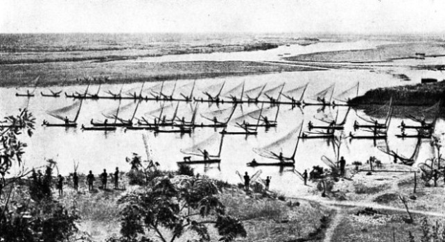
FISHING CRAFT on the River Congo in French Equatorial Africa. Above and below Stanley Pool the right bank of the river is in French Equatorial Africa and the left bank is in Belgian Congo. Near the mouth the right bank is in Belgian and the left bank in Portuguese territory. In some areas the local people depend almost entirely on the river for their food as they live mainly on fish and hippopotamus flesh.
Poisoned arrows were shot at the boat, and a desperate fight which lasted for three days delayed Stanley. Then the party travelling along the bank came up and Stanley led a force across the river and captured thirty-
They were attacked at every village they passed. Men died from disease every day but they won their way to what, is now known as Stanley Falls, where the savages gathered expecting to see Stanley go to his death. But the indomitable man managed to get his boats safely past the seven cataracts. He found that the river curved to the north-
Respite from attack came when the river opened out to a width of four miles and a belt of islands. By taking channels between the islands the voyagers were screened from the watchers on the banks, but directly the screen of islands was passed the savages attacked again. The explorers fought their way out. The river curved westward and then south-
At the lower end of the pool the river narrowed into a series of rapids. They dragged the canoes by land past each fall and tried again in smoother water, but accidents occurred almost every day. The canoe containing Pocock was swept over one rapid and he and the men with him were drowned. On two occasions Stanley was swept over falls, but he escaped with his life. At last he reached a place which he recognized as the point which Captain Tuckey had described. He knew that he had solved the problem of the Congo.
Stanley’s long voyage down the Congo had shown him the drawbacks as well as the possibilities of the vast waterway. The main obstacle was the succession of rapids below Stanley Pool. Once the rapids were avoided by a road or, better still, by a railway, steamers could be placed above them to travel on a 1,000-
An Ambitious King
King Leopold II of the Belgians had colonial ambitions. Even before Stanley reached England agents of the king met him at Marseilles to invite him to Brussels to confer with King Leopold, but Stanley went to England, confident that the British would develop the great waterway. He was disappointed. He made repeated efforts but failed to secure any support. Then he responded to King Leopold’s invitation and took service with him.
Stanley was placed in charge of the private organization formed by the Belgian king and told to go ahead. First he went to Zanzibar and recruited seventy men, forty of whom had crossed Africa with him. Then he went to the mouth of the Congo, recruited men locally and gathered a small body of European assistants. Four small paddle steamers, barges, steel boats, corrugated
iron wagons, stores and provisions were sent out from Europe. Stanley went up to the head of navigation above Boma and built his first station, called Vivi.
The next step was to drive a road through mountainous country, which took a year at the rate of a mile a week. Stanley taught his men to drill holes and blast the rocks with charges, and so gained his local name of Bula Matari, the Breaker of Rocks. After the second station a stretch of eighty-
He had, however, been forestalled by de Brazza, who had raced inland from the sea and bought the land for the French, so Stanley secured the south bank and built the station called Leopoldville. Another bout of fever followed and he returned to Europe, the preliminary work having been completed. He urged that a railway should be built to avoid the rapids and that concessions be obtained from chiefs along the whole of the river. Then he went back to the Congo to establish a chain of river stations from Stanley Pool to Stanley Falls.
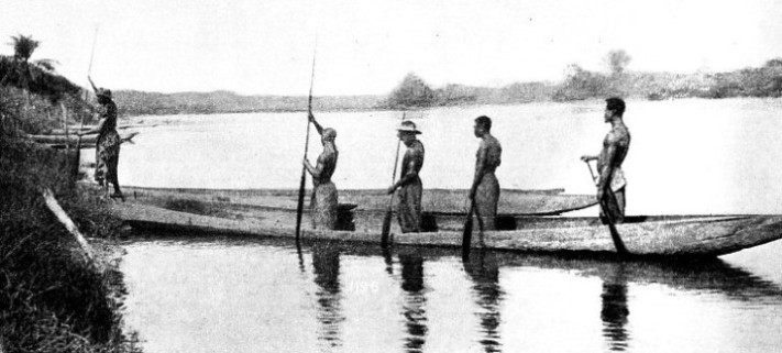
DUG-
On his return he found that the men he had left in charge had for the most part failed in their duty. His first task was reorganization. Then he left Leopoldville and went up the river with his little steamers for the 1,000-
Again the drums throbbed over the mysterious river, but this time they told of the wonders of the steamboats and of the cloth and goods with which these were laden. Stanley made treaties with over 400 chiefs on his way to the falls, leaving a chain of stations in his wake.
Stanley left the Congo in 1885, his work of founding the new State having been completed. Some two years later he returned to the Congo, but only to use it as a path to cross Africa, this time from west to east. He was at the head of an expedition sent to relieve Emin Pasha. He went up the river to a point below Stanley Falls, then went up a tributary, the River Aruwimi, as far as there was water for his boats, and then overland. Stanley was the ablest of the river explorers of modern times. He survived all hardships and died at his home at Pirbright, Surrey, in 1904.
His pioneer work in the Congo was continued by various explorers. Railways were built to avoid the cataracts and as auxiliaries to the Congo and its tributaries. Above Stanley Falls to Ponthierville there is one up-
Another link of railway goes hence to Kongolo, where the river is again navigable for forty-
Fuel for the steamboats in remote districts is wood, which is cut into lengths of 4 feet and stacked in cords or “brasses”. One of the difficulties has been to get the natives to cut the wood. In the early days they did not want to work. Since then, however, the women have wanted cloth and trinkets and to get these the natives have had to provide wood, palm oil, rubber and other articles to trade with the Europeans. At one time the system of forced labour for gathering rubber was notorious. After the system had been exposed, the Congo Free State passed out of the private control of Leopold II and, in 1908, became the Belgian Congo under the Belgian Government, which instituted reforms. Owing to the depredations of ants and other insects the river craft used by Europeans are built of steel or iron. Locally, men continue to build boats according to local methods. Some of these craft are up to 100 feet in length, the longer ones being two dug-
The men are expert watermen and the larger boats have a good turn of speed. The men have their boat songs and chants to give time to the strokes of the paddles. For speed they take their time from the beat of a drum. The drum is the great means of communication all along the river and can be used for relaying a message right across Africa or for carrying on local conversation. If men in a canoe on the river hear a distant drum one of them relays the message on the drum in the canoe.
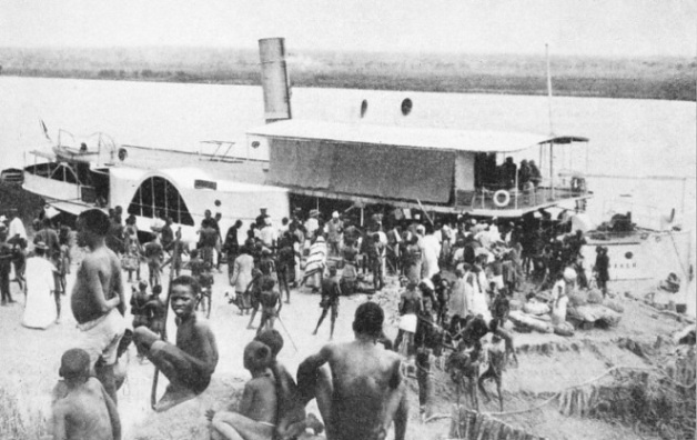
THE NORTH-
Every village has its town drum placed on blocks under a thatched roof. The river acts as a sounding board enabling the town drum to carry a surprising distance. It is said that the
drums have sometimes outstripped the official radio service. During the war of 1914-
The trading companies on the river use whale-
As the channels are constantly changing the river steamers moor to the bank at sunset. A man dives overboard with a hawser, swims with it to the bank and makes fast to the trunk of a tree. Europeans occupy the cabins on the upper deck, and the crew, cargo and fuel are carried on the lower decks. The Unatra Company is the most important river transport firm. Its fleet amounts to
a total of more than 50,000 tons deadweight.
The journey from Stanleyville, below Stanley Falls, to Kinshasa, the port on Stanley Pool, takes from eight to sixteen days according to the state of the river and the speed of the boat. The waterway is not monotonous and the steamer stops several times a day to pick up passengers and cargo. The trading stations, or factories, usually consist of a few bungalows and stores built on a strip of road on the bank of the river.
Navigable Tributaries
Below Stanleyville the first place of importance is Basoko, where the Aruwimi joins the Congo. This is a fortified post which was of great value to the Belgians, for this place is in the heart of the cannibal country. Below the settlement the Congo broadens to a width of about twenty-
The rivers Lulonga, Busira, Ubangi and Kasai flow into the main stream and stain the brown river with bands of colour, for the waters they bring to it are of varying tints. All the waters are churned together in the gorge above Stanley Pool. Coquilhatville is a town formerly called Equatorville as it is just above the Equator at the confluence of the Ruki with the Congo.
Before Stanley Pool is reached the Kasai joins the river from the Belgian side, forming yet another network of navigable waterways. It flows into the Congo at Kwamouth, where the Congo narrows into a gorge 125 miles long with the cliffs rising in places to 800 feet.
The swift stream carries the steamer into Stanley Pool. The French are building a railway to Pointe-
Every river steamer has been brought past the rapids in sections to Stanley Pool to be reassembled under the guidance of Europeans. The crews are the sons of the cannibals who tried to eat Stanley. The pioneers of the river were white men from all corners of the world. These men opened up the path into the heart of Africa.
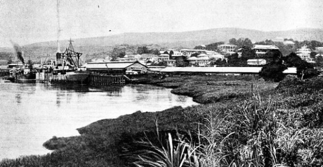
THE PORT OF MATADI is the limit for ocean-
You can read more on “A Gallery of Native Craft”, “The Nile”, and
“Romance of the Trade Routes” on this website.