
© Shipping Wonders of the World 2012-

The Welland Canal
The new Welland Canal, a masterpiece of modern engineering, is the fourth of a series of canals designed to link Lake Ontario and Toronto with Lake Erie and the rest of the Great Lakes system

TORONTO WATER-
One of the most wonderful engineering feats achieved since the completion of the Panama Canal is the fourth Welland Ship Canal in Canada. The canal crosses the Niagara peninsula about ten miles west of the famous Niagara Falls. It is the fourth of the series of canals which for more than a century has formed a vital link in the chain of water transport that extends from the heart of Canada to the North Atlantic.
The canal connects Lake Erie with Lake Ontario, on the northern shore of which stands Toronto, the second-
Perhaps more famous than any other waterfall in the world, the Niagara Falls were an impassable barrier to the river craft of the pioneers. The falls strangled all water transport from five of the great lakes above them to the sixth lake below them and thence down the St. Lawrence River to the sea. Rapids elsewhere could be overcome by towing or by short portages, but Niagara was too gigantic to be mastered by such methods. Goods had to be transported overland for a considerable distance. The people of the Niagara district therefore determined to cut a canal.
Work was begun in 1824, and in 1829 two schooners, one of which was Canadian and the other from the United States, passed through the first canal, which had forty wooden locks. This canal made use of two creeks and was extended a few years later, in 1833, but traffic soon outgrew it. Later the wooden locks were reduced in number and replaced by stone locks, a new section of canal was cut and this, the second Welland Canal, was completed.
Then was built a third canal, which was used by vessels of up to 255 feet in length and 44 feet beam. In its turn this canal became too small and its limitations prevented the large ships on Lake Erie from passing through to Lake Ontario. A fourth canal, the route of which was different from that of its three predecessors, was decided upon, and after many delays due to the war of 1914-
The time of transit has been reduced from about 16 hours for the old canal to about 7½ hours, and the number of locks from twenty-
Because of the contour of the land the locks are not evenly distributed along the canal. Seven locks are on the Lake Ontario side of the Niagara escarpment, the eighth being the gigantic guard lock on the Lake Erie side. At various points along the canal docks have been built to provide facilities for municipalities and factories. Just above the lifting locks a huge guard gate and safety weir have been built as a safeguard against flooding. Nature is being used to aid the navigation of the canal, as large numbers of trees have been planted. These trees are growing into a forest screen which will form a wind-
Wind causes considerable variations in the level of Lake Erie at Port Colborne, sometimes of as much as 11 feet, but this factor is not permitted to affect the canal. The gigantic guard lock, Lock No. 8, has been built to counteract these variations and to maintain the summit-
The lift of this lock is determined by the varying level of Lake Erie and is usually between 3 and 4 feet. The summit-
The Lake Ontario terminus of the earlier canals was at Port Dalhousie, and the terminus of the new canal at Port Weller is about three miles to the east. This necessitated the building of an artificial harbour, as there was no natural one. Each of the seven lifting locks is 859 feet long between the inner gates, the usable length being 820 feet. The locks are 80 feet wide, the usable width being 79 feet, with 30 feet of water on the sills.
Summit-
At the southern end of Port Weller Harbour is the first of the locks, the second being 1¾ miles inland and the third 2¾ miles beyond that. The course of the canal is virtually a straight line to the foot of the Niagara escarpment at Thorold. The canal climbs the hill by four locks, Nos. 4, 5, 6 and 7, without deviation from the direct route. The first three locks lift the canal 139½ feet to the base of the hill, which has an abrupt rise of 186 feet. Here is the steepest section of the canal.
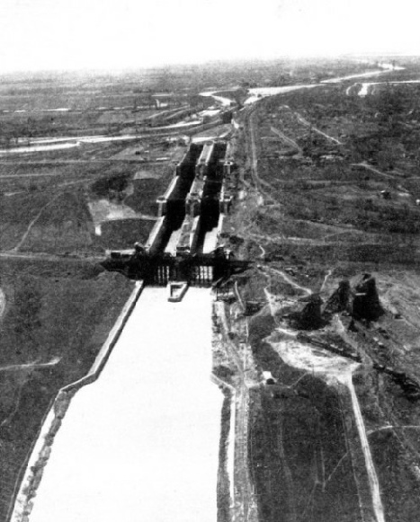
Three of these four locks, Nos. 4, 5 and 6, are twin locks in flight, providing two traffic lanes, one for upward-
Elaborate measures have been taken to safeguard the canal. A guard gate and safety weir have been built about three-
 By an ingenious system it is not possible for the guard gate to be opened at the same time as the upper gates of Lock No. 7. In the unlikely event of the gates of Lock No. 7 being carried away the guard gate and safety weir would enable the waters of the summit-
THREE TWIN LOCKS in flight at Thorold afford facilities for ships going in either direction to use the locks at the same time. The Welland Canal has a total length of 25 miles, excluding harbour entrances, and ascends 325 ft. 6 in. in a series of eight locks.
To prevent vessels from accidentally ramming the lock gates, fenders are stretched across the locks, each consisting of a 3½-
During the months when navigation on the Great Lakes is suspended because of ice the canal is closed, but at all other times it is used night and day, and is lighted from end to end. In the long reaches the lamps are 450 feet apart; they are 200 feet apart at the lock approaches and 160 feet apart on the lock walls. Automatic telephones are installed. Port Colborne, the Lake Erie terminus, had to be improved and enlarged, as it had been the terminus of the third canal. The outer harbour is formed by two breakwaters about 4,400 feet from the shore, and a new breakwater, over 2,000 feet long, was added to the western breakwater. The harbour channels have been deepened.
The canal crosses the third canal twice between Port Weller and Thorold. Between Thorold and Allanburg a new cut was made to straighten the route, and from Allanburg to Port Robinson the route is that of the third canal. From Port Robinson to Welland the route is to the east of the third canal and follows the west bank of the Chippewa Creek, which has been diverted at several places. At Welland the canal crosses the creek, and as the summer level of the creek is 6 feet lower than that of the canal the waters of the creek are passed under the canal through a concrete siphon culvert. From Welland to Ramey’s Bend the third canal was widened and deepened, and to eliminate the Bend the new canal was built almost straight to Port Colborne.
The operating gates for the locks are of the mitring horizontal girder type, sheathed on either side and built of steel, the leaves being 48 feet long and 5 feet thick.
Twenty railway and road bridges carry the east and west traffic arteries of the peninsula across the canal. Most are vertical lift bridges with a clearance of 20 feet above the water. All are operated by electricity and can be opened in 1½ minutes.
An important feature is the hydroelectric power station built at the foot of the flight locks on the west bank. This station supplies the entire canal with power for operating the lock and bridge machinery and the current for lighting and heating. Water brought from an intake at the head of Lock-
Striking Traffic Increase
During building operations, navigation was carried by the third canal, and as soon as various sections of the new canal on the summit-
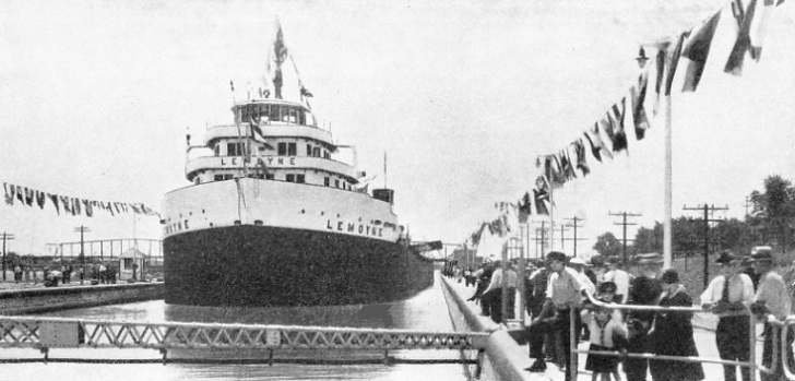
The opening ceremony took place at Lock No. 6 on August 6, 1932, and the vessel which passed through was the Lemoyne, owned by the Canada Steamship Lines, Ltd., and then the largest freighter on the Great Lakes.
Such a masterpiece of engineering as the Welland Canal is necessarily costly and more than £24,000,000 was spent on the canal up to March 31, 1934. Shortly after the opening, traffic increased by half. In 1930, the year which marked the end of the third canal as an entirety, traffic was 6,100,000 tons. This increased to 9,280,452 in 1934 and the Welland Ship Canal had over half the total traffic of all the Canadian canals. In 1935 the canal was used by 2,293 vessels downward-
Across Lake Ontario, 26 miles from Port Weller, is Toronto, the second-
The port has been developed to provide miles of deep water wharves. The western entrance channel is 24 feet deep and available for the largest ships on the Great Lakes. Smaller craft use the eastern channel, the depth of which is 14 feet.
Navigation seasons are governed by the opening and closing dates of the Welland and St. Lawrence Canals and are usually from early April to the middle of December. Steamship lines link Toronto with Montreal and with Canadian and United States lake ports. In the year ended March 31, 1935, 2,893 vessels with a total register tonnage of 3,446,423 arrived and departed, and not one vessel was a sea-

THE LARGEST GREAT LAKES FREIGHTER passed through Lock No. 7 of the Welland Canal to perform the opening ceremony on August 6, 1932. The Lemoyne was carrying 500 009 bushels of wheat on a draught of 19 ft. 6 in. Of 10,480 tons gross, the Lemoyne has an overall length of 633 feet a beam of 70 ft. 3 in. and a depth of 25 ft. 5 in.
You can read more on “Adventures of the Ice-