

© Shipping Wonders of the World 2012-

Ross in the Antarctic
With the famous sailing ships “Erebus” and “Terror”, Captain Sir James Clark Ross, the intrepid explorer and keen scientist, sailed through the pack-
 OF ALL South Polar voyages, unquestionably the greatest and yet one of the least-
SCIENTIST AND POLAR EXPLORER, Captain Sir James Clark Ross, R.N., was born in 1800 and died in 1862. He was a nephew of Sir John Ross, the famous Arctic explorer. In June 1831 Sir James Ross had discovered the North Magnetic Pole, and his famous Antarctic expedition ten years later was an attempt to discover the South Magnetic Pole.
Ross’s expedition was the second to be sent out officially by the Admiralty to explore the Antarctic regions. The first expedition consisted of the Resolution and the Adventure, under Captain Cook, in 1772-
In 1830 and succeeding years, scientific men all over the world began to show great interest in terrestrial magnetism. Data had come in from all parts of the globe except the Antarctic. Gauss, the great German mathematician, had deduced that the South Magnetic Pole was probably situated in about 66° S., 146° E. The British Association, in a memorial presented to the Government in 1838, pressed strongly for the dispatch of a Naval expedition to reach this position or, at least, to obtain magnetic observations at as many points in the Far South as possible. The Association’s object — unattainable without such observations — was to make a world-
That Ross should be appointed to command the proposed expedition was inevitable. No other Naval officer — no other man then living — was so well qualified for the post. Ross’s Polar experience was unrivalled. In the course of many years’ Polar service under Sir Edward Parry and Ross’s uncle Sir John Ross, he had spent sixteen summers and eight winters in the Arctic. In addition, he was an experienced magnetic observer and an explorer of note who had already distinguished himself by reaching the North Magnetic Pole in June 1831. He was also a man of considerable scientific training, and his work on terrestrial magnetism had won him the coveted honour of Fellow of the Royal Society. Lastly, he was a fine seaman and a good disciplinarian.
Ross was appointed to the command on April 8, 1839. The Admiralty provided him with two remarkable ships, the Erebus and the Terror. These vessels afterwards became famous in connexion with Franklin’s ill-
The Erebus (370 tons) was new to Polar work, but the Terror (326 tons) had already seen Arctic service under Captain George Back, R.N., in 1836-
The crews (sixty-
While the ships lay in the River Medway, the little schooner Eliza Scott (154 tons), owned by Enderbys of London, returned from a year’s sealing cruise in the Antarctic. Her captain, John Balleny, was thus just in time to give Ross first-
During Ross’s voyage, magnetic observatories in many parts of the world were taking special daily observations. Ross carried huts, instruments and observers sufficient to equip observatories at several spots where such did not already exist. In addition, the ships carried instruments enabling magnetic observations to be taken at sea, and portable observatories which were set up at points where the expedition might call. The combination and analysis of the results showed clearly that every movement of the needle, say, at Kerguelen Island, in the south of the Indian Ocean, corresponded with a simultaneous movement at other stations such as Toronto, Canada, almost diametrically opposite to it.
Inhospitable Kerguelen
The explorers sailed from the Cape on April 6, 1840, bound for Kerguelen. Fog and head winds made a call at the Prince Edward Islands impossible and limited their stay at the Crozets to a few hours — just long enough for them to receive a visit from a party of sealers, who looked “. . . more like Eskimos than civilized beings, but filthier far in their dress and persons.”
By May 3 they were off the bleak, storm-
 During forty-
ROSS’S ANTARCTIC VOYAGE in the Erebus and the Terror started from Hobart, Tasmania, on November 12, 1840. From Auckland Island Ross sailed south to Victoria Land. The smaller map shows the course of the expedition in the Ross Sea, where the ships were held up by the Great Ice Barrier.
Ross left Kerguelen without regret on July 20, and the ships ran eastward in about 47° 8. to Tasmania. The “Roaring Forties” lived up to their name. During a heavy gale on July 30 Roberts, the boatswain of the Erebus, was blown overboard out of the rigging. Benumbed and stupefied by the cold, he sank when the two boats that had been lowered were close upon him. The crew of one boat, swamped by a breaking sea, almost shared his fate. By August 16,1840, the Erebus and the Terror were at Hobart, Tasmania, getting ready for their first campaign in the South. Sir John Franklin, already famous as an Arctic explorer, was then Governor of Tasmania, and lent Ross every possible help to complete his scheduled observations and to prepare his ships for their ordeal in the ice. At the same time he provided him with important and disquieting news about foreign competition in unknown Antarctic waters.
Britain was not the only nation then engaged in Antarctic exploration. France had sent Captain J. S. C. Dumont d’Urville, with the Astrolabe and the Zelee; the United States had sent a squadron of five ships under Lieutenant Charles Wilkes. D’Urville and Wilkes had both sailed long before Ross — the former in September 1837 and the latter in August 1838. So much Ross already knew. But he was disagreeably surprised to learn that the two men had just returned from the very region which his instructions directed him to explore — the area due south of Tasmania, in which Gauss had theoretically located the South Magnetic Pole.
D’Urville had sailed from Hobart on January 1, 1840, and had discovered land (“Adelie Land”) lying on the Antarctic Circle (66° 33' S.) not far from Gauss’s position. He had taken possession of it for France. Wilkes, who had been ordered to veil his proceedings in almost complete secrecy, was credited with having discovered and examined a huge coast-
Ross was inclined, at first, to dismiss the account of Wilkes’s discoveries as mere newspaper exaggerations. But at Hobart he received a cordial letter from the American commander, who enclosed a tracing that showed his recent discoveries in detail. This fully substantiated what Ross had already heard about them.
Neither Wilkes nor d’Urville, however, had penetrated farther southward than the Antarctic Circle. Neither of them had ships capable of contending against the pack-
On November 12, 1840, the Erebus and the Terror sailed out of Hobart to begin their great adventure. Ross first made for Auckland Island. Here he took magnetic observations and found two notice-
Fifteen Icebergs in Sight
They met their first iceberg on December 27 in 63° 20' S. By the evening fifteen were in sight — the huge, flat-
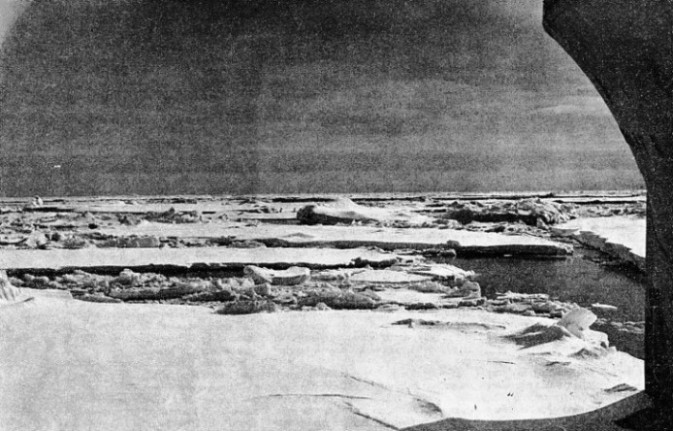
On New Year’s Eve a line of low ice was seen from the masthead. It proved to be the northern edge of the pack. This is a vast stretch of floating ice fragments, some as small as boats, some as large as any ship. It is interspersed with occasional bergs and constitutes an armour-
Former explorers, Cook and the Russian Bellingshausen, for instance, sealers and Ross’s own rivals d’Urville and Wilkes — all, as a matter of common prudence, had kept well to northward of the ice-
The Erebus and the Terror, however, had been specially fortified for work in the pack; and Ross was not the man to turn back in the face of any danger that stood between him and his duty. That night he crossed the Antarctic Circle, and for the next four days he carefully examined the pack-

IN COLLISION DURING A SNOWSTORM, the Erebus and the Terror were for a time at the mercy of the wind and the icebergs. Two icebergs had suddenly loomed up in the falling snow and the Erebus was forced to head to port in the path of the Terror. The ships collided and the bowsprit and fore-
Fortune favoured him as he deserved. After an hour’s battering, the ships made their way into a series of small “holes of water” —little areas, clear of floating ice, which gave them room to manoeuvre. These were connected by “leads” — narrow lanes of more or less open water along which they picked their way. It was risky work. The two vessels, because of their bluff bows and coarse lines, were exceedingly slow sailers — the Terror particularly so.
Although their great beam enabled them to carry all plain sail in half a gale of wind, neither ship was capable, at any time, of more than 8 knots. Not only were they slow, but also they were sluggish, unhandy, difficult to put about quickly, and “dull” even in answering the helm. To thread them through the pack required not only incessant vigilance but also a mind quick to note and interpret the slightest indication of impending changes in the ice distribution and in the weather. So long as a stiff breeze blew, their chances were good; but a gale in the pack meant incessant hammering from huge masses of ice which they could not possibly dodge. A calm would bring them no respite, for the swell kept the floes in constant motion, while at the same time it debarred them from sending their boats ahead to tow.
This time, however, the wind held generally fair for them, with only brief intervals of calm. They had almost reached the southern edge of the pack-
seen from the masthead. First of all men, they had won their way through the Antarctic pack. It was an epoch-
Ross made all sail, steering southwestward, although Gauss’s theoretical Magnetic Pole lay a little to the northward of west. Throughout the voyage the Erebus and the Terror had carried on magnetic observations under sail as well as when in harbour. Whenever he could spare time from his other duties, Ross had been hard at work analyzing the results, consulting his magnetometers and his records, plotting lines of dip and variation, and outlining “isodynamical ovals”.
Farthest South
An eighteenth-
As it was the first land discovered in the young Queen’s reign, Ross named it Victoria Land. By evening he was within a few miles of the coast, off a prominent cape (Cape Adare), from which the shore trended to the northwest and to the south. Ross determined to follow it southward, as in any event he would then reach higher latitudes — and if he could round its southern extremity and turn westward he might still hope to reach, or closely to approach, the South Magnetic Pole.
First of all, however, he must take possession. This he did early next morning, when he landed on a small island near the ice-
Ross named the spot Possession Island, and steered southward, keeping as near the coast as he could and charting it as he went. It was everywhere barren and snow-
On January 22, 1841, the Erebus and the Terror reached 74° 20' S., breaking the “farthest south” record established in 1823 by James Weddell, a British sealer, who had the unique experience of finding the sea which now bears his name completely free of pack-
Compelled to keep wide of the coast by the heavy pack adhering to it, Ross landed (January 27, 1841) on a detached island in 76° 08' S., 168° 12' E., which he named after Sir John Franklin. While standing due southward from Franklin Island the ships were confronted by the most extraordinary spectacle of the whole voyage. A long way ahead of them there gradually arose a huge, conical, snow-
From the foot of the land dominated by the volcano, which Ross named Mount Erebus, and by a smaller, extinct companion, named Mount Terror, there ran off to eastward a low, white line extending as far as the eye could reach. Ross took it to be heavy pack-
Impenetrable Ice Barrier
Further progress southward was out of the question. As Ross put it, he might just as well have tried to sail through the cliffs of Dover. So he bore away to the eastward along the Barrier face.
Although Ross coasted it for 250 miles, keeping as close in as was practicable, and often in grave danger of being crushed between the ice-
It had been left to Ross’s discretion whether he should winter in the Antarctic — no one had yet done this — or in Tasmania. A protracted search of the coast-

STRANGE ICE-
Enlivened at night by brilliant displays of the Aurora Australis, the two ships zigzagged northward. They sighted the Balleny Islands on March 2, and then hauled to the westward. By Wilkes’ chart they were not far from the eastern end of the mountain range, backing the coast-
Later examination has shown that, with the solitary exception of Adelie Land (previously discovered by d’Urville) no part of Wilkes’ “Antarctic Continent” exists where he charted it. Undoubtedly he was often near the land, and he did a fine piece of work, in most unsuitable ships, by keeping so close to it for 1,500 miles; but he was only once within sight of it.
By April 6, 1841, Ross was back at Hobart after his great voyage. Despite incessant hard work, his ships were in good condition and he had no men on the sick list. He had broken through the pack, he had been farther south than any man before him, and he had discovered a vast new territory, an active volcano in the heart of the Antarctic, and the great Barrier. Apart from this, in his first independent command as an explorer he had proved himself the ideal leader — possessed of rapid decision, an unfailing judgment approaching intuition, and an iron nerve.
Franklin, who knew what such splendid achievements connoted, was the first man to greet and welcome Ross. When tidings of his work reached Europe, Ross was awarded the gold medals of the London and Paris Geographical Societies, the highest honours in their power to bestow. The Admiralty showed its appreciation by immediately promoting Crozier, his second in command, and Bird, his first lieutenant, on Ross’s recommendation.
Beset in the Ice-
During the winter, the Erebus and the Terror refitted at Hobart for their second campaign in the ice.
The refit completed, Ross took his ships to Sydney, and thence to the Bay of Islands, New Zealand, for comparative magnetic observations. He sailed from New Zealand for the south on November 23, 1841, intending to resume his exploration of the great Barrier to the eastward from the point where he had left off in February.
A bitter disappointment was in store. Ross ran southward in about 146° W. — much farther east than before — and
encountered the pack in a much lower latitude, 60° S. Although a month later, by incessant effort, he had forced his ships to 66° S., he was still in the pack, with no immediate prospect of getting clear. On January 19, 1842, it blew a terrific gale. Although under bare poles, the ships were almost dismasted by the incessant blows of the ice-
Quite early on the two ships lost their rudders. The Terror's was completely destroyed, and that of the Erebus so damaged as to be useless. Yet as soon as the worst of the gale was over, while one watch was sent below to get some rest, the other set manfully to work repairing damages. The Erebus hoisted in, repaired and replaced her shattered rudder in eight hours. The Terror put together and shipped her spare rudder and contrived to build, out of what materials the vessels could afford, a completely new rudder, which was set aside for use as a spare.

A FRENCH ANTARCTIC EXPEDITION under the command of Captain J. S. C. Dumont d’Urville sailed in August 1833 to the waters that Ross was to explore in the next five years. This illustration shows the sailors from d’Urville’s ships, the Astrolabe and the Zelee, trying to clear a passage in the ice-
The ships remained pent up in the pack for another three weeks. On January 28 observations for position — the first they had managed to get for some time — showed that they were in 67° 39' S., 155° 59' W. After having driven through 800 miles of pack-
Eventually, after fifty-
Ross stood towards Victoria Land and then north-
Ross threw his ship aback to deaden her way as much as possible, but the impact was terrific. The bowsprit of the Erebus was snapped off short and her fore-
In the Direst Peril
The starboard bower anchor of the Erebus was forced bodily into the side of her hull and remained hanging there, suspended by its flukes. Meanwhile the two ships, entangled in each other’s rigging and dashed helplessly together at every moment, were drifting bodily down upon the bergs, in almost total darkness, before a roaring gale.
Providentially, they cleared each other in the nick of time. Crozier headed the Terror, which was not much damaged, to safety through the gap between the bergs. But the Erebus was not far from being helplessly disabled. The wreckage of the bowsprit and foretopmast prevented any sail from being made on the foremast, so that Ross could not get headway on his ship. She was so
close to one of the bergs that her lower yards struck its cliffs every time she rolled. Some of her officers afterwards admitted that they could not remember what orders they received or gave during this appalling crisis. But Ross was as cool as if he had been yachting.
He “made a sternboard” — a manoeuvre most seamen would have been chary of executing in such weather, even with a well-

“SMOKE” OVER THE ROSS SEA. The temperature of the water in the Antarctic is often warmer than that of the air. This causes a form of haze which drifts across the open waters that are occasionally to be found in the ice-
After this ordeal, Ross stood northward to get clear of any other icebergs, and then eastward for Cape Horn. He was bound for the Falkland Islands, where he had arranged to refit — but a second fatality awaited the Erebus before she made port. During a gale in the early hours of April 2, 1842, James Angelly, a quartermaster, fell overboard from the main-
The ships reached the Falklands — a dreary change from the gaieties of Hobart — on April 6. They had been four and a half months out of sight of land. Here Ross stayed until September, carrying out his usual programme of observations and giving his battered ships a thorough overhaul. He managed, after some delay, to obtain a new bowsprit for the Erebus from Rio de Janeiro. He sailed on September 8 for Cape Horn, where more magnetic work was done. Then he returned to the Falklands to pick up mail and dispatches from home that had previously gone astray. Then, on the morning of December 17, 1842, the Erebus and the Terror sailed for their final campaign in the ice.
Ross selected as his first point of attack the long island-
After the ships had several times been in imminent danger between the shore and the pack, Ross turned eastward, hoping to find, as Weddell had done in 1823, an open sea somewhere near the meridian of 40° W. But, as we now know, the Weddell Sea is only clear of pack-
A Last Assault
Ross continued eastward until, on February 28, 1843, he was within 100 miles of the route along which Bellingshausen, in 1820, had reached 69¾° S., 2° W. There was no room for any important discovery between the two tracks and, as the season was already late, Ross determined to make one final assault on the pack — which he had hitherto skirted — without standing any farther eastward. Accordingly, he altered course to the south-
March 3 was perfectly calm — a rare event in the Antarctic — and Ross proceeded to sound with 4,000 fathoms of line without, apparently, striking bottom. His Ross Deep remained on the charts until 1904, when Dr. W. S. Bruce in the Scotia obtained a sounding of 2,660 fathoms with a modern sounding-
MODERN ANTARCTIC EXPLORATION employs strong power-
In the evening the wind got up and Ross again stood to the south-
In the early morning of March 11, 1843, the Erebus and the Terror recrossed the Antarctic Circle for the last time, making for the Cape of Good Hope. As they went they saw a huge beam of light, which they took at the time to be a farewell display of the Aurora Australis. Afterwards this proved to be the tail of the Great Comet of 1843, one of the largest and brightest comets that have ever been seen.
Although he was on the way homeward, Ross’s zest for exploration was unabated. He ran eastward along latitude 54° S. with the intention of solving, if possible, an Antarctic mystery just over a century old.
On January 1, 1739, the French explorer, J. B. O. Bouvet de Lozier, leader of the first expedition equipped by any nation to explore the Antarctic regions, sighted what he believed to be a promontory of the “Great Southern Continent” in which many geographers
then firmly believed. He named it “Cape Circumcision” (after the day of its discovery, January 1), and gave its position as about 54° S. and somewhere near the longitude of 9° E.
In 1772 Cook in the Resolution passed southward of this position, and showed that if “Cape Circumcision” existed it could only be part of a small island. In 1775, moreover, he made a careful search along 54° S. from 6° E. to 22° E. without success, and concluded that what Bouvet had seen was really a large iceberg. Cook’s colleague, Furneaux, also searched unsuccessfully for the island in 1774.
Antarctic Mystery
On the other hand, in 1808, one of Enderbys’ sealers, Lindsay, in the Swan, reported that he had been in sight of the island for a week and that it lay in 54° 15' S. and about 4° 15' E. Another of their captains, Norris, of the Sprightly, not only sighted the island in 1825, but landed on it on December 16, 1825, and took formal possession in the name of King George IV. By his report it was situated in 54° 15' S. and 5° E., not far from Lindsay’s position.
Ross did not, at the time, know of Lindsay’s work, or Norris’s; but the island was shown on his charts as “position doubtful”. To clear up the point he ran along 54° 15' S. from about 6° W. to 6° E., thus linking up his search with that of his great predecessor Cook. He saw no trace of any island, and endorsed Cook’s opinion that “Cape Circumcision” had been a large iceberg, although he was afterwards inclined to reverse this judgment when he heard of Norris’s landing.
Yet the Cape exists to-
The Erebus and the Terror reached the Cape of Good Hope on April 4,1843, and made their way thence to England after a short refit. They paid off at Woolwich, London, on September 23, having been four years and five months in commission.
Ross was called out of his semi-

AN ACTIVE VOLCANO IN THE ANTARCTIC. Discovered by Ross in 1841 and named after one of his ships, Mount Erebus is 12,373 feet high. A neighbouring extinct volcano (10,909 feet) was named Mount Terror after Ross’s other ship. In the foreground is a group of Adelie penguins on an ice-
You can read more on “Exploring the Ocean Depths”, “The Franklin Mystery” and
“The Voyages of Captain Cook” on this website.