

© Shipping Wonders of the World 2012-

New York: Key to a Continent
All the world’s fastest steamship services from Europe to the United States converge on the Port of New York, with its magnificent natural harbour on the Atlantic seaboard of the North American continent
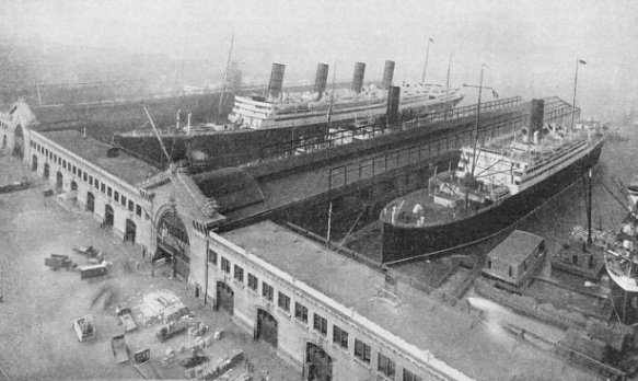
CUNARD WHITE STAR PIERS on Manhattan Island, facing the Hudson River. Even the largest vessels can sail up this river to the heart of the city. Of the ships seen in the photograph the largest -
THE Port of New York is the gate to the entire continent of North America. Such is the vastness and complexity of New York that many people in other countries are confused by certain local peculiarities which make it different from other great ports.
The area of the jurisdiction of the Port of New York Authority is greater than that of New York City and Greater New York. It includes part of two distinct States -
New York City is a sky-
On the European side of the North Atlantic the Western Ocean traffic is divided between a number of big ports, and the passenger or shipper in Europe has a selection of routes, but if he wishes to go to North America New York is the port he must use if he wants the quickest route. He may book his passage from Southampton, Liverpool, Glasgow, Havre, Hamburg, Rotterdam or a Mediterranean port, but he enters North America at New York. Moreover, for purposes of freight, New York is one of the most convenient of the North Atlantic ports.
Although New York City, built on Manhattan Island, is the financial, commercial and shipping capital of the United States, Washington is the political capital, and Albany, on the Hudson River, is the capital of New York State. Manhattan is one of the five boroughs of the city of New York. The other four boroughs are the Bronx, on the mainland north-
The natural facilities make the harbour one of the best in the world. It is landlocked, on a large river, the Hudson. The channel had ample water until the development of the big ship demanded dredging.
From the beginning, New York has had no need to build breakwaters and other artificial means of protection Nature has provided her with ample shelter, and despite the growth of the port, there is still room for expansion.
The total water-
For large vessels the Ambrose Channel is the principal entrance to the port. It is seven and a half miles long from deep water to the Narrows (described below), 40 feet deep and 2,000 feet wide and is used by most ships coming from Europe. There are other channels south of the Ambrose, including the Main Ship -
1,000 feet wide. This channel is used by the scows that carry the refuse of New York to the dumping grounds at sea. The Ambrose Light is the starting or finishing point of Atlantic speed records, because the pilot is dropped or taken on there.
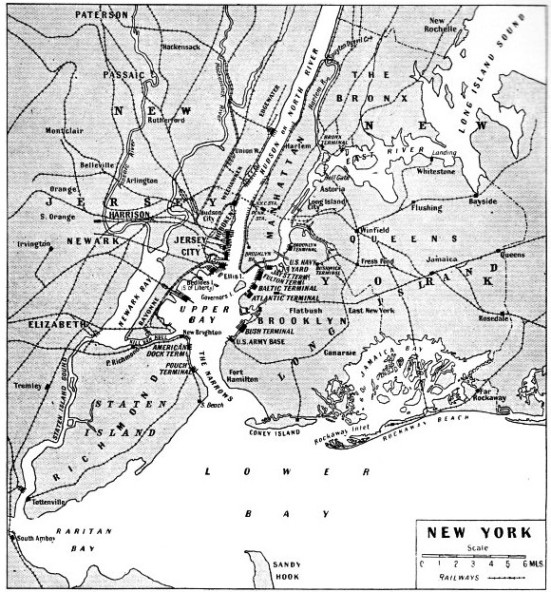
THE GEOGRAPHICAL POSITION of New York, with its great land-
New York is approached through the Lower Bay, 88 square miles in area, and the Upper Bay, 14 square miles in area. These two bays are connected by the Narrows, a mile-
Passing the Narrows between the boroughs of Richmond and Brooklyn, incoming ships sight the Statue of Liberty on Bedloe’s, or Liberty Island, opposite Governor’s Island. Ellis Island, where immigrants are examined, is beyond, and then rise the skyscrapers of New York City. Ocean liners from Europe generally berth at the piers on the western side of Manhattan Island, in the North River, as the Hudson River is called in New York. Across the river, to the west, are the piers of Hoboken.
Manhattan is the heart of New York. On this island the great buildings have reared skyward because they could not spread outwards. This makes New York the most imposing of cities, but its traffic problems are complicated. Every person bound to or from Manhattan has to cross water, by bridge, tunnel or boat. The Hudson River separates Manhattan from New Jersey, the narrow Harlem River cuts it off from the rest of New York State, and the East River divides it from Long Island. Manhattan Island is about thirteen and a half miles long with an average breadth of one mile and three-
The piers are on Manhattan, on the Hudson and East Rivers, on the New Jersey shore, and on Staten Island and Long Island. In 1930 the water-
The story of New York begins in the autumn of 1609, when an 80-
Attack by Indians
Hudson was looking for the North-
The merchants of the Netherlands acted upon Hudson’s report, and enterprising traders followed in the wake of the Half Moon. They founded trading posts on the tip of Manhattan Island, on the mainland and as far up the Hudson River as Fort Orange, which afterwards became Albany. Adrian Block, one of the mariners who followed Hudson, had the misfortune to lose his ship by fire while she was anchored off Manhattan. He and his men felled forest trees and built a 45-
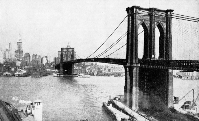
BROOKLYN BRIDGE spans the East River and joins Long Island and the borough of Brooklyn to Manhattan Island. The bridge was opened in 1883. The main suspension span is 1,595 feet long between towers. The total length of the bridge, including the approach viaducts, is 5,989 feet, a distance of more than one mile.
The Dutch called this settlement on Manhattan Island, New Amsterdam. It was founded in 1613. Eight years later the Dutch West India Company was chartered, and the territory of New Netherland was given to it. In 1624 Peter Minuit, director, or governor, of the colony arrived. A year or so later he bought Manhattan from the Indians for ribbons, beads, clothes and baubles estimated to be worth less than a five-
These early Dutch were sharp traders, and knew the value of furs, but they were not farmers. The British settlers, who were farmers, took deeper root and thrived more surely. The British always maintained that the Dutch had no right on the North American continent because Cabot had been there first. Charles II gave the territory occupied by the Dutch to his brother James, Duke of York. When a British fleet arrived, the Dutch surrendered in 1664.
New Amsterdam became New York, and Fort Orange became Albany. By this time there was one dock called the Hooft on Manhattan, and slaves from Africa were employed as dock workers. All incoming ships hove-
The Dutch recaptured New York with a fleet in 1673, but the city passed back to the British the following year under the terms of the Treaty of Westminster. Thus what is now one of the largest English-
Under the British flag New York had a turbulent career. When news was brought of the flight of James II in 1688 the city flared up into a local rebellion that lasted for two years. One party held that the authority of the king had ended and that New Yorkers should appoint their own officials. The others contended that the officials should continue in office until new appointments were made by King William. There were bloodshed and executions until order was restored.
Then New York entered upon a strange phase. The city prospered by privateering and selling powder, shot and supplies to acknowledged pirates. The port was ideal during the almost incessant wars between Britain and France for any mariner with a stout ship, a tough crew, guns, powder and shot. The whole seaboard of North America afforded opportunities for these New York freebooters. To the north were the French settlements in Canada, with the French shipping to raid, and to the south were the buccaneers of the West Indies with whom New York did a thriving trade. In the Indian Ocean Madagascar became a stronghold of the pirates who preyed upon the rich ships from the East. New York captains could buy Jamaica rum at two shillings a gallon in New York, sail it to Madagascar and sell it for three pounds a gallon. From the Governor downwards everybody shared in the profits of trading with pirates.
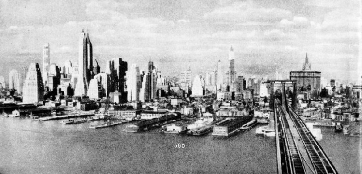
THE FAMOUS “SKY-
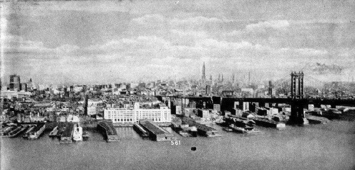
MANHATTAN BRIDGE, on the right of the photograph continued above, connects the borough of Brooklyn with the island of Manhattan, nucleus of New York City. The section illustrated on this page is similarly lined with docks, but the skyscrapers are less numerous. On the east, Manhattan Island is separated from the boroughs of Brooklyn and Queens by the East River, and from the borough of Bronx by the Harlem River. On the west of Manhattan is the Hudson River, opening into Upper Bay. In this bay are the famous statue of Liberty and Ellis Island, the immigrant station.
A ship would sail out of New York as a privateer entitled to engage any vessel flying the flag of a nation at war with Britain. If she failed to find such a vessel, the captain sometimes turned pirate. Dead men told no tales and, by slaughtering the crew of a captured ship, the pirate would destroy the evidence against him and could return to New York as a privateer. Many of the vessels were slavers. New York was a port without manufacturers, and depended upon the sea for her existence. The taverns along the water-
For seven years during the War of Independence New York was in the hands of the British. Before the Revolution there was constant friction between the seafarers of the port and the British. The seafarers, who always risked being kidnapped by the press gangs of the British Navy, lost no opportunity of fighting the men of the Royal Navy or of the Army garrison, and many lives were lost in these encounters. For a short time after the Revolution New York was the temporary capital of the Republic. When the British marched out in 1783 it was a port of 23,000 inhabitants, many of whom were negro slaves. By 1810 the population had increased to 95,000. A set-
It was from New York that Robert Fulton’s Clermont earned fame in 1807 by steaming 150 miles against wind and current to Albany, up the Hudson River, in thirty-
Astor was a German immigrant, but Cornelius Vanderbilt was descended from the Dutch of New Amsterdam. As a youth he sailed a ferry boat from Staten Island to New York and he soon realized the advantages of steam. He saved every nickel and went into steam, building larger and faster ferry boats and charging cheaper fares than any of his competitors. In this way he amassed a fortune. He founded a line of steamships to Havre and then withdrew from the sea and put his capital into railways.
During this period other New Yorkers were experimenting with the idea of speed. Certain merchants inaugurated the Black Ball Line of sailing packets between New York and Liverpool and began the era of fast sailing ships. This was in 1816. Steam was still too unreliable and too novel for the remorseless surge of the rollers of the Atlantic, so these pioneers pinned their faith to tall masts and clean wooden hulls. They reaped ample dividends. The world began to realize that while at sea passengers and cargo are not earning money. People began to understand that a speed of five knots was not the limit of speed at sea, under sail.
About the middle of the last century New York was the focal port for the American clippers. Fast sailing ships linked the port with Europe, or sailed round the Horn to San Francisco or to China, and steamers took gold-
Meanwhile clever brains were at work in New York, and eyes were turned inland as well as seaward. It is an axiom that the cheapest form of transport is by water. New York is south of the Canadian ports of Montreal and Quebec on the St. Lawrence River, and the Gulf of St. Lawrence is closed by ice in winter. The project of tapping the Great Lakes route to the heart of the continent by using the Erie Canal was put in hand.
This canal linked Buffalo, at the eastern end of Lake Erie and at the head of the Niagara River, with New York through the valleys of the Mohawk and Hudson Rivers. It brought a constant stream of traffic to New York. It was a great enterprise for those days and was opened in 1825. As the waters of Lake Erie entered the canal, the signal was sent to New York by the firing of cannon placed at intervals along the canal and the Hudson River.
By the time that railways began to develop, New York had become so populous and thriving that no other port on the seaboard could compete with it as the eastern terminal of the railways and as the western terminal of the shipping lines from Europe. The city had altered beyond recognition during its rapid growth. The American-
The traffic problem of the port became complicated. Only one of the trunk railways had the right to build its goods terminal station on Manhattan. Seven other railways terminated in New Jersey, one in the Bronx, one on Long Island and one on Staten Island. Railway companies built their terminals on the water-
Since the arrival of the railways the districts at the terminals have developed, and it would not be possible for the railways to buy land for expansion at an economic price. The Port Authority has planned a scheme to improve facilities and to ease the waterborne traffic.
Owing to the depth of water and the sheltered position of the port, vast breakwaters and an expensive system of docks were not required. The only necessity was to build piers or jetties. There are more than 800 piers, from 200 feet to 1,800 feet in length and from 80 feet to 200 feet in width. The big liners on the Atlantic run berth at the piers of their companies on the Manhattan side of the Hudson River, as the East River is too narrow to allow the construction of long piers. The piers on the East River accommodate vessels trading to Europe, the West Indies, the Gulf and the U.S. Coast.
The mile-
opposite the business centre of Manhattan. Brooklyn and its neighbouring borough, Queens, are linked with Manhattan by bridges and tunnels across the East River. The first bridge was Brooklyn Bridge, opened in 1883. The main suspension span is 1,595 feet long between towers, and the total length, including the approach viaducts, is 5,989 feet.
 The Hudson River is spanned by the magnificent George Washington Bridge between 178th Street, Manhattan, and Fort Lee, New Jersey. This bridge was opened in October 1931, and work was completed in October 1932.
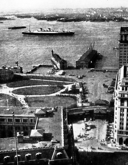
THE UPPER END OF BATTERY PARK, at the south-
The Bush Terminal in South Brooklyn is one of the most famous terminals in the port. It is situated on the Upper Bay above the Narrows and has piers, warehouses, factories, tugs, lighters and road and railway facilities. In New York City the goods made in the factories at the terminal are displayed to buyers, and orders are delivered from the terminal. The Atlantic and Baltic Terminals, U.S. Army Base, and Jay Street Terminal are among the terminals on the Brooklyn shore. On the Staten Island side are the American Dock and the Pouch Terminals. On the New Jersey side of the Hudson River are the numerous piers of the railway companies, and many piers at which berth the liners and freighters of the principal companies connecting with Europe and other continents.
At one time navigation of the East River was difficult because of the currents, especially at the Hell Gate, near the confluence of the Harlem River and the East River, and many craft were wrecked. Rocks and reefs were blasted out of the way and Hell Gate was subdued. The flood tide, however, still runs at five statute miles an hour. Beyond Hell Gate the strait widens into Long Island Sound. The Harlem River, which divides Manhattan Island from the New York mainland, is crossed by various bridges, and connects with the Hudson River at Spuyten Duyvil Creek. It has a channel 15 feet deep and 400 feet wide.
The increase in the size of great liners has caused many developments in the port of New York. At one time the length of the Hudson River piers on Manhattan was limited to 900 feet, but this limit has been extended to accommodate the super-
The anchorage mainly used by foreign vessels is in Upper Bay, and includes an area of 3,000 acres westward of a line marked by white anchorage buoys from Ellis Island to the Greenville Channel of the Pennsylvania Railroad Company. The eastern part of this area, for a width of 2,000 feet, is a temporary anchorage for large ships awaiting a berth, but occupancy may not exceed seventy-
It is necessary to resort to more figures to convey an idea of the size of the port of New York. There are 214 piers for ocean-
The 121 piers on the Manhattan front of the Hudson River have a maximum depth alongside of 42 feet, and are occupied by the bulk of the passenger and express freight vessels. On the Manhattan side of the East River there are 108 piers, devoted mainly to the West Indies and Gulf services. On the opposite shore of the East River are 101 piers in addition to ferries, car-
The maximum depth alongside these piers is 40 feet. The Brooklyn shore of Upper Bay is occupied by the Bush and other terminals already referred to, and there are dry docks and repair facilities. On the Staten Island shore of Upper Bay are the Quarantine Station, the United States Coastguard Station and the thirteen Stapleton Piers, which are owned by the City of New York and leased to tenants. These piers are all over 1,000 feet long, and from 125 feet to 200 feet wide, with 30 feet of water alongside.
The water-
Many piers on Manhattan and elsewhere are owned by the Municipality of New York, and controlled through the Municipal Department of Docks.
There are ample facilities for loading and discharging at berth direct to lighters or wharves, and, at railway pierheads, to railway trucks. There are free lighterage limits, within which goods consigned inwards or outwards by railway are entitled to free delivery. The incoming passenger is more concerned with the stupendous sky-
New York is the supreme port of the New World, and behind it lies the largest English-
Click here to see the photogravure supplement to this article.
You can read more on “The Great Lakes”, “Great Ports of the World”, and “The Manhattan and the Washington” on this website.
You can read more on “New York’s Giant Bridges” and “Tunnelling the Hudson” in Wonders of World Engineering