The safe navigation of ships in every corner of the Seven Seas depends mainly on the accurate and painstaking work of a handful of surveying vessels which collect information for the making of charts
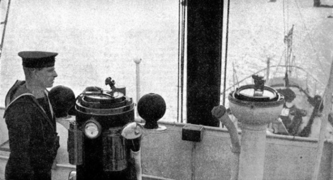
ON THE BRIDGE of H.M.S. ENDEAVOUR, engaged in survey work. The seaman is looking at the magnetic compass, which is the ship’s standard. On top of it is the azimuth-mirror for taking bearings. The dial in front of the wooden compass-stand is the heeling-indicator. The brass canisters on either side of it house the binnacle-lamps. To the right is the gyro-compass repeater, the gyro-compass itself being below the water-line. The gyro-compass points about sixteen times as powerfully as the magnetic compass.
OF those who use the sea probably few ever spend much time in thinking of the enormous amount of labour which goes and has gone, for more than a century past, to the production of the charts which they use daily They would be lost without them. Yet they expect, as a matter of course, in whatever part of the Seven Seas they may find themselves, that they will always be able to obtain, at a moderate cost, an Admiralty chart which is strictly accurate and up to date. The chart must show the coast, with all its outlying dangers, such as reefs and shoals, the lights, buoys, and beacons, the principal channels and, above all, the exact depth of water to be found in any position. They have been able to obtain this information for such a long time past that, they see nothing wonderful in it — for them it is a daily commonplace.
Wherever the navigator goes he can never (unless he manages to cross the magic line marked “farthest South reached hitherto” on some of the Admiralty charts of the Antarctic) come to a shore which has not already been visited and charted by a surveying ship, or, at least, by one sailing “on discovery”. The work has been done, the coasts of the world have been charted, and he is reaping the benefit.
The magnitude of that work can be appreciated only by consulting the catalogue, and some specimens, of such a modern collection of published charts as the 4,000 issued by the British Admiralty. France, Germany and the United States also publish sets of charts embracing the-whole world.
This enormous body of information, accurate to a degree which is almost incredible, results from the work of a handful of little ships. They work far from the limelight, devoting their days to obscure drudgery whose nature few understand or are competent to appreciate. Their only reward is the production of a new chart now and then, and the knowledge that, because they spend their time thus, the seamen of all nations can go safely and prosperously about the world’s seas. By the nature of things — and by the workings of Nature — their labours are never-ending. However well some particular area may have been surveyed the resulting chart will, strictly speaking, be out of date before it is published, and must be successively revised until, many years later, a re-survey relegates it to the haven of forgotten things. None the less, every survey must be as accurate as time and pains can make it.
The beginnings of accurate marine surveying coincide with the rise to fame of Captain James Cook, R.N., F.R.S., probably the greatest- discoverer who has ever lived. Before Cook’s time many seamen had produced maps of the harbours they had found and the coasts they had skirted. The Admiralty Library, for instance, has several thousand manuscripts and printed maps of the kind. These maps, however, had no pretensions whatever to accuracy as the modern navigator understands it. In the hands of anyone except their authors they were an additional source of danger rather than a safeguard.
It is in the St. Lawrence and Newfoundland charts produced by Cook in the ten years preceding 1769, when he sailed with the famous Endeavour (a name still borne by a British surveying ship), on the first of his three great Voyages round the World, that we see the results of the first really accurate marine surveys. Cook’s earliest chart, for example, that of the St. Lawrence River,was based on a triangulated survey of the principal points. It has always been a mystery where and how, in the limited amount of spare time at his disposal, Cook had acquired the necessary knowledge of geometry and trigonometry to undertake such a piece of work. In his Newfoundland and Labrador surveys, too, he is known to have used a theodolite, an instrument of which, in his day, few seamen had even heard.
The difference between Cook’s surveys and the general run of those made by his predecessors and contemporaries was this: that if Cook had been sent to survey a place the authorities could rest assured that the job would not need to be done again, and that that part of the world would not require re-surveying for a long time. For example, the need of re-examining and amplifying his original surveys of Newfoundland and Labrador, and of some parts of New Zealand and Australia, was not seriously felt until the present century.
The utmost faith could be placed in his charts, but navigators were better off without most of the others. And as this fact gradually came home to the various Admiralties, the old rule-of-thumb, haphazard ways of chart-making began to be steadily ousted by more accurate methods.
This, however, did not occur immediately and not, at first, in home waters. Cook’s chart of New Zealand, for instance, executed under heavy difficulties in 1769-70 — in the course of six months he surveyed the whole coast-line, 2,400 miles long, with the slow-sailing Endeavour — is much more accurate, in outline and detail, than any map or chart of the British Isles published before about 1800. During the century following Cook’s death, marine surveyors of all nations went far afield to win their laurels. The shores and the islands of the Pacific were still largely unexplored. Thither went French explorers such as the gallant, ill-fated La Perouse and his great successor, Dumont d’Urville, Russians such as Krusenstern and Bellingshausen, Spaniards (de Heceta and Azara, for example), and the unique United States Exploring Expedition of 1838-42.
The lion’s share of the work of surveying the unexplored or imperfectly-mapped coasts of the world fell to Great Britain. The -record is too long to give in any detail here, but it embraces, for instance, Captain Vancouver’s five-years’ survey of the north-west American coast in 1791-95, one of the most extensive, elaborate and thorough surveys ever made.
Charting the World
There were also Fitzroy’s surveys, of similar extent and duration, in Patagonia, the enormous amount of exploration done in the Arctic during the protracted and fruitless searches for Franklin and his men, and in the Antarctic by Ross during his great voyage of 1840-43, and the achievements of the Challenger (1872-76) during the greatest single oceanographical voyage ever made (for which see the chapter “Exploring the Ocean Depths”). In the course of that century there was scarcely a corner, or an island, of the Seven Seas left unvisited and uncharted by a British surveying ship.
Those days will never come again. There is little left to discover and, except in the Polar regions, surveying ships are no longer free to go where they wish. A British survey of the Argentine and Chilean coasts, for example, such as that performed in the Beagle by Fitzroy a century ago, would be impossible to-day. Such work must now be done and is done by such nations for themselves. But even within the limits of the British Empire there is ample survey work remaining for several times the number of ships at present engaged in it — and the wonder is, that with such limited means the work should be done so rapidly, and so thoroughly, as it is. Other nations are no better provided with surveying ships than Great Britain — witness the following table:
SURVEY SHIPS OF THE WORLD’S NAVIES, 1936
British Empire 12
Argentina 3
Brazil 3
China 5
Denmark 2
France 10
Germany. . 1
Greece 1
Italy 3
Japan 2
Latvia 1
Holland 4
Poland 1
Portugal 2
Spain 3
Sweden 1
Turkey 1
U.S.A 1
There are also 12 surveying ships belonging to the Coast and Geodetic Survey Bureau of the U.S. Department of Commerce.
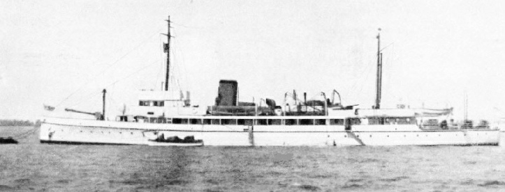
CONVERTED FROM A MINESWEEPER into a surveying vessel, H.M.S. Kellett was built in 1919 at Renfrew, Scotland. A twin-screw vessel of 800 tons, she has an overall length of 231 feet, a beam of 28 ft. 7 in. and a draught of 7 ft. 6 in. She is armed with one three-pounder and has a complement of eighty-eight. Her speed is 16 knots. The navies of the British Empire own in all twelve surveying ships.
At the present day, therefore, fewer than seventy small ships carry out the work of surveying all the coasts of the world. Their work includes the making of new surveys, the amplification of former ones, and the detection and charting of previously undiscovered dangers and of the periodical changes which are brought about, almost daily, by the action of the sea or by the hand of man.
The great surveys of the past were mainly executed with what Herbert Spencer once described as “implements singularly ill-adapted to the purpose” — with slow, unhandy sailing-ships, ill-found, ill-equipped and under-manned. Although the modern steam surveying ship is always small and rather crowded, she is usually handy and well-equipped. In the matter of instruments required for her special purposes — such, for example, as chronometers, searchlights, range-finders, gyro-compasses, wireless telegraphy and echo-sounding apparatus, to name only a few — she can often give points to many ships ten times her size. Her petty officers, too, are generally picked men, in receipt of special pay (as “recorders”), and her officers — at least those of the executive branch — are specialists who have elected to devote their Naval careers to hydrography. Formerly, an officer might go from surveying to ordinary duties with the Fleet, and then return to surveying, but nowadays the specialized nature of all Naval activities makes this impracticable, and the rule is “Once a surveyor, always a surveyor”.
In almost every instance, a modern marine survey is an extension of or an amendment to one previously made. The survey may be of a coast whose topography has already been thoroughly laid down by land surveys. In such instances the marine surveyor is saved a good deal of work, since he can connect the salient positions used in his survey with other points whose exact sites are already known and mapped.
Even on land, it would be a ruinously expensive and unbearably tedious business to make an accurate survey of an area more, say, than a square mile or so in extent by direct measurement from point to point. Instead, recourse is had to triangulation. All over the area, marks are erected in well-defined positions forming a chain of triangles whose sides may be several miles in length. At the site of each mark the angles respectively subtended by suitably chosen pairs of the other marks are carefully measured with the theodolite.
These angles once obtained, the whole system of marks may be plotted on paper of any convenient size, each mark appearing at its correct distance and bearing from the others. Starting, say, from an initial base-line formed by the line joining two of the marks, the angles to a third mark observed from the ends of that base-line define the position of that mark — and the sides of the triangle thus drawn become the bases of three more triangles. Moreover, if the original base-line be once carefully measured on the spot, no other direct measurement will be required at all. The exact distance apart of any two points throughout the whole chain of triangles can always be found by calculation.
Floating Beacons
How accurate this process, when well executed, can be is well shown in the records of the Ordnance Survey. For the original triangulated survey of the British Isles, a base-line several miles long was measured off along the shores of Lough Foyle, Ireland. The network of triangles extended across the Irish Channel to the remotest corners of England and Scotland. As a test, the length of the base-line as observed by angles taken to its extremities, and deduced from these angles by calculations carried through the entire circuit of triangles, was compared with its length as found by direct measurement, with metal bars compensated for temperature. The difference was
about two inches. The surveyor s first job, therefore, once he is anchored off the surveying ground, is to erect his primary marks, or “main stations”, and measure his base-line. As compared with the land-surveyor, he works at a great disadvantage, for his choice of positions for the marks is much restricted. Often he has to place them where he can, there being no land where he would prefer to have them — and in such instances his triangles may have to be “ill-conditioned”, containing acute angles that are difficult to lay down accurately on paper.
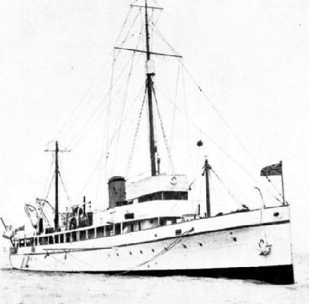
BUILT AT RENFREW IN 1919, H.M.S. Flinders, with the Kellett (illustrated above), the Beaufort and the Fitzroy, was originally designed as a minesweeper. The dimensions of these vessels are identical. Driven by vertical triple-expansion engines of 2,200 indicated horse-power, they have a speed of 16 knots.
Sometimes when working off-shore among detached, submerged reefs a long way from land, he may find it impossible to set up any fixed marks, and be compelled to fall back upon moored floating beacons. In that event, no accurate triangulation is possible. Usually, however, he manages to establish a fairly suitable set of main stations for his triangulation. Then he goes to each in turn, and “shoots up” all the others with the theodolite. He uses the theodolite whenever he can, but some of the marks may be so awkwardly placed that he has to fall back upon the seaman's staunch friend — the sextant. A triangulation made with a good sextant, whose errors are accurately known, is not much inferior to one done with the theodolite.
Two of the main stations will have been carefully selected to serve as the end-points of the base-line. The distance between them is now most carefully measured, generally with a surveyor’s chain or an “invar” wire. In emergencies, however, the base may have to be measured by astronomical observations, or by “mast-head angles”, or even by sound-signals, with a considerable loss of accuracy.
The next step is to erect a “tidepole” and to take continuous observations of the height of the tide hourly or even oftener, day and night. This is of vital importance. The whole of the sea-area included in the survey will have to be examined by sounding — chiefly from the ship’s boats, with the hand-lead — and unless full information is available as to the exact height of the tide at any given time during the sounding-out, such soundings will be perfectly useless.
If the effects of tide were to be neglected, for instance, a sounding-boat might return the least depth of water available in a given channel at anything from, say, 15 feet to 5 feet, depending upon whether her examination was made at high water, at low water, or at some intermediate time. Unless data were at hand for reducing all such soundings to a common standard, they would be a source of great danger to navigation. The main triangulation having been made, and the base measured, the work — so far as it has progressed — can be plotted on paper, and that left to be done allotted to separate parties. One of these takes in hand the “secondary triangulation”. The main triangulation has fixed with great accuracy the positions of a few prominent points, but only a few, insufficient in themselves to determine either the outline of the coast or the contours of the land. Large numbers of “secondary stations” are therefore marked, by poles or any other method. With rocks a bucket of whitewash, “ the surveyors’ friend,” comes in handy. These stations are connected, by angles, with the main stations.
The coast-line and the land contours are mapped out in this way and carefully plotted. At the same time the exact positions are carefully noted of all conspicuous objects — detached houses, windmills, churches, sometimes even clumps of trees — and every object visible from seaward which can be readily identified and used, as an element of a cross-bearing, to determine a ship’s position.
Importance of Soundings
Meanwhile another party or parties will have taken in hand what is probably the most important part of any marine survey — the soundings. The spectacle of a detached party leaving a surveying ship in the early morning for a day’s sounding or coast-lining is admirably calculated to give the average Flag Officer apoplexy. The work is hard and tedious — but there are compensations, and one of them is a sensible relaxation of the usual Naval regulations relating to such matters as dress and smoking during the five working days of the week. The parties leave in any old outfits — the men in coaling or painting rig, the officers in their oldest plain clothes — plus-fours and a pullover, perhaps, or (in the tropics) shorts and a battered sun-helmet. Nor is there, generally, any pedantic veto upon smoking during working hours, or even while at work.
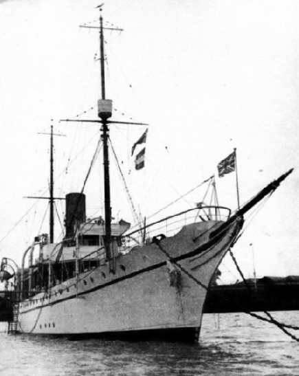
SPECIALLY BUILT FOR SURVEY WORK at Glasgow in 1912, H.M.S. Endeavour is a vessel of 1,280 tons. She has an overall length of 241 ft. 3 in., a beam of 34 ft. 2 in. and a draught of 11 ft. 8 in. Her complement is 140 and her speed 13 knots.
The soundings shown on any chart are its most essential feature and are also the most striking point of difference between a chart and a map. Laying down the coast-line, and the conspicuous objects, will enable a ship to determine whereabouts on the chart she is — but it is the soundings, and those alone, which can tell her whether the position in which she is, or any other, is safe for a ship of her draught. Monotonous though the work must be, sounding demands the utmost vigilance. However carefully the work may have been done, it cannot be certain that all dangers will have been found, for some “pinnacle rocks” rise straight from the bottom, as if they were huge needles, and their sides are so steep that the sounding-lead will not rest on them. Equally, when consulting the chart, the navigator has to remember that however closely the soundings on it may be spaced, each of them individually represents the depth over an area only equal to that of the bottom of the lead — about two square inches. Moreover, as a rule, it is a waste of time to obtain more soundings than can afterwards be shown on a chart.
A careful watch, however, is kept on the soundings when they are first plotted. They are usually taken from boats to the nearest foot, along spaced lines, the boat’s position being frequently checked by angles. Any unusual shallowing in an area whose depths are generally uniform is the signal for an even closer examination of its vicinity. As a final precaution a wire-drag hung from buoys to a predetermined depth may be towed over the area. If it fouls nothing, it thereby indicates that there are no undiscovered dangers existing within at least that distance from the surface
Pinnacle Rocks
How difficult, and how expensive, the discovery of pinnacle rocks, even in well-frequented waters, may be, a few instances will show. In September 1922 H.M.S. King George V was severely damaged by striking an uncharted pinnacle rock in the Moselim Channel, north of Mitylene, in the Aegean Sea. The rock lay right in the centre of the track used daily by deep-draught vessels. In the same year the French battleship France, while entering Quiberon Bay, north of St. Nazaire, France, along the line of bearing specifically recommended on the French charts for vessels of deep draught, ran on to a similar rock and sank in two hours. Subsequent examination revealed a second similar rock, on the same line of bearing and about 100 yards farther on.
It also came to light that many years earlier the coastguard warship Hoche had hit a third rock of the kind, not far away. In this instance a special survey of the vicinity had been put in hand, but it had been discontinued, “for reasons of expense”, when it was a few yards from the rock which later sank the France. The saving of a few thousand francs had cost the French nation a new super-dreadnought.
The little-known story of the Avocet Rock in the Red Sea has no equal in the history of marine surveying. The Rock lies in 14° 22' 08" N., 42° 41' 32" E., sixteen miles from the eastern shore of the Red Sea and out of sight of land except in the clearest weather. Although covered by no more than 15 feet of water at L.W.O.S.T. (Low Water Ordinary Spring Tides), and lying right in the centre of the trade-route up and down the Red Sea, its existence was unsuspected until 1887. Three searches made for it subsequently, two of them by surveying ships, were unsuccessful.
On March 4, 1887, the steamer Avocet, laden with iron rails, was steaming southward down the Red Sea when she experienced a slight shock and promptly began to fill with water. Her crew, luckily, were all rescued by another steamer, the St. Oswald, which had been in company with her for some hours and was not far off. An official inquiry held at Aden endorsed the Avocet’s story —that she had been lost through striking on an unknown rock in about 14° 21' N., 42° 38' E.
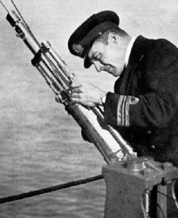
AN INSULATED WATER BOTTLE being adjusted in H.M. surveying ship Challenger. Important information relating to such matters as currents is gathered from samples of water or solid matter lifted from the sea-bed by such hydrographical instruments, which must be of great strength to prevent implosion (bursting inwards).
As, however, this position lay close to the deep-water track, and as evidence was available to show that other ships had passed on either side of the Avocet and the St. Oswald just before and just after the accident, the Admiralty declined to accept this judgment, particularly since H.M. surveying ship Flying Fish had searched the vicinity a few days after the Aden inquiry, finding more than 100 fathoms of water. The Admiralty, therefore, requested the Board of Trade to hold a further inquiry, in London, into the cause of the Avocet’s loss.
The Court sat, but not for long. At its first meeting, on June 10, 1887, a telegram was handed to its President, stating that the Teddington had foundered, “after striking an unknown rock”, not more than 5 miles north-east of the Avocet’s position. The Court thereupon dissolved, and the Admiralty sent H.M.S. Griffon to examine the reported position (14° 23' N., 42° 42½' E.) of the new disaster. She spent a week working from the Teddington’s position to the Avocet’s and back again, sounding incessantly and dragging a length of chain-cable astern, but she found no rock, nor even any indications of shallow water.
The positive evidence for the rock’s existence, however, was too heavy to be outweighed by the negative result of two searches, and in October H.M. surveying ship Sylvia was detailed to make an exhaustive examination of the region near the Teddington’s position. The Sylvia prosecuted her search for six weeks, but no trace of any submerged danger approaching the surface more
closely than 28 fathoms (168 feet) could be discovered in the vicinity. Undeterred by the complete failure of three successive searches, the Admiralty directed H.M. surveying ship Stork to re-examine a small, deep shoal found by the Sylvia. Early in 1888 the Stork found, 300 yards from where the Sylvia had lain at anchor, a small coral rock, now known as the Avocet Rock, with no more than 15 feet of water on it at low tide. It was nearly half-way between that ship’s position (as afterwards corrected) and the one given by the Teddington. So small is its summit that even in heavy weather the sea round it does not break. But for the pertinacity with which the Admiralty kept on hunting for the rock until it was found, many other ships must have shared the fate of the Avocet and the Teddington.
The Hydrographic Department
With the completion of the soundings, the end of the survey — so far as concerns the work done in the field — is in sight. Meanwhile, astronomical observations have been taken, either with the sextant or with the prismatic astrolabe to determine the absolute latitude and longitude of one or more of the main stations. By this means the corresponding latitude and longitude of any point within the limits of the triangulation can, if necessary, be calculated. Observations have also been taken to determine the “variation” of the compass, of its deflection from true North, and the position of true North relative to the baseline.
Finally, when the surveying season is over, the ship returns to civilization. Her officers settle down to “drawing the fair charts”, preparing their work for publication in the form of a chart or charts, with the accompanying commentary of “sailing directions”.
The connecting link between the work of the surveying ships and the sea-going public is, and has been since 1795, the Hydrographic Department of the Admiralty. Starting as a small office of two rooms, with a staff of three — the Hydrographer (Alexander Dalrymple, F.R.S.), an assistant and a draughtsman — it has now come to occupy a considerable portion of the present Admiralty building. Two important branches, the Chart Branch and the Tidal Branch, are domiciled in Cornwall House, London, and the printing is done at the Admiralty Chart Establishment, Cricklewood. The Department publishes, and keeps up-to-date, some 4,000 separate Admiralty charts with their accompanying sailing directions, lists of lights, tide tables, and a mass of other hydrographic information of vital importance to seamen, including the Admiralty Notices to Mariners.
Such is the manner in which the modern Admiralty charts, and those of other nations, come into being. They embody, in condensed and handy form, a mass of accurate information, slowly accumulated over many years.
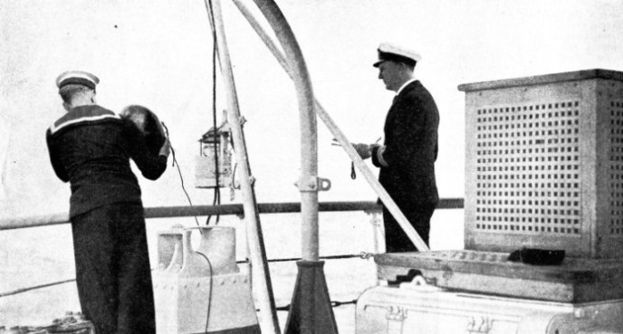
MEASURING STRENGTH OF CURRENT in H.M.S. Endeavour. The seaman is holding a float, with a light line attached, which he is about to “stream” — that is, to throw overboard. The ship is anchored in the current, and as the float drifts away it will take the line out — this being allowed to run freely. The officer will note the exact time of streaming the float; when a stated period has elapsed he will order the line to be held. The amount run out, combined with the time, gives the necessary data for working out the speed of the current. The method is that of the old-fashioned “hand-log”, which is still sometimes used for current observations.
You can read more on “Exploring the Ocean Depths”, “Instruments of Navigation”, “Navigational Charts” and “The Voyages of Captain Cook” on this website.


