The great land-locked harbour of Vancouver forms Canada’s gateway to the Pacific Ocean. In the lifetime of one man Vancouver has grown from an insignificant log-camp into a modern commercial centre.
GREAT PORTS OF THE WORLD - 6

THE MODERN CITY of Vancouver. This photograph of the Granville district was taken in 1936. Fifty years earlier this site was a small village and a lumber camp, as shown in the illustration at the foot of the opposite page. The first section of Burrard Inlet, on which the city is situated, is five miles long from the channel known as Lions’ Gate to the Second Narrows, on the right of the photograph above. The shores of North Vancouver are two and a quarter miles distant across Burrard Inlet.
VANCOUVER is the commercial metropolis of the Province of British Columbia, and the third largest city in the Dominion of Canada. It is situated on a peninsula, along “a very narrow border of low land”, as Captain George Vancouver described it when he surveyed the shores of Burrard Inlet in 1792. Vancouver juts out into the Gulf or Strait of Georgia almost in the shape of a shark’s head, with the city proper located on the upper jaw and the residential section on the lower. Between the jaws lies English Bay, and curving over on the snout are the nine hundred acres of primeval forest known as Stanley Park.
The story of the birth and growth of Vancouver forms one of the most romantic and striking chapters in the record of modern endeavour. Late in the sixteenth century, Sir Francis Drake, searching for a north-west passage, reached the coast of what are now the States of Washington and Oregon. He named it “New Albion”. In 1778 Captain James Cook landed at Nootka, on the west coast of what is now Vancouver Island. His discovery of this coast opened up a lucrative fur trade, and the North Pacific became the happy hunting ground of the merchant adventurer. In 1788 Captain John Meares established a fur-trading post at Nootka. This was captured by the Spaniards and for a time became an important Spanish base; but, by the treaty known as the “Nootka Sound Convention”, signed in 1790, this district passed finally into the hands of Great Britain.
The next year Captain George Vancouver, commanding the new 340-tons H.M.S. Discovery, and accompanied by the armed tender Chatham, sailed for this coast. His instructions were to explore the coast-line and take possession “of the buildings, districts or parcels of land which were occupied by His Majesty’s subjects in the month of April, 1789.” In a small ship’s boat propelled by sail and oars, Captain Vancouver passed on June 13, 1792, beneath the bold bluff now known as Prospect Point through a narrow channel into a deep, placid harbour. This was the mouth of an inlet twenty miles long, and Captain Vancouver named it Burrard Inlet. Through this same inlet there now pass every year no fewer than 17,000 vessels from every quarter of the globe.
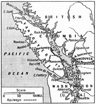
PROTECTED FROM THE OPEN SEA by Vancouver Island, the Port of Vancouver is the Pacific terminus of the Canadian Pacific Railway. Ocean-going vessels leave the Strait of Georgia and reach the Pacific Ocean through the Juan de Fuca Strait. Coastwise vessels ply from Vancouver to almost every fjord on the broken coast-line of British Columbia.
To-day fifty-five ocean steamship lines make Vancouver a regular port of call. During 1934 the total tonnage entering the port amounted to 11,488,452. The harbour, forty-eight square miles in area, is one of the world’s largest natural harbours, with a total shore-line of ninety-eight miles. Railway and ocean docking terminals, grain elevators, lumber mills, cold storage and refrigerating establishments, sugar refineries, abattoirs and meat-packing plants, dry docks and ship-repairing yards line the channel. In addition there are many iron foundries and marine engineering works, as well as railway shops, oil refineries and flour mills. Other factories in Vancouver produce paper products, chemicals, wire-rope and lumber commodities.
The forest-clad shores of Burrard Inlet remained in their virgin solitude until 1862, when three young Yorkshiremen, John Morton, Sam Brighouse and William Hailstone, who had sailed across the Atlantic in the famous Great Eastern, landed with the intention of seeking their fortunes in the British Columbian goldfields. Morton spent the night on shore and decided to settle there. In 1863 two men from the port of New Westminster, on the Fraser River, erected a water-power lumber-mill on the north shore of Burrard Inlet, and round this mill the village of Moodyville grew up. Two years later Captain Stamp established the Hastings Sawmill on the south shore, and thus founded the village of Granville. Granville, Moodyville and Hastings are to-day the main districts of Vancouver.
Mr. William C. Van Horne, Vice-President and General Manager of the Canadian Pacific Railway syndicate, came to the Pacific coast in July 1884 to acquire land for the terminus of the railway. He chose Vancouver as the most convenient situation. The coming of the railway was the prime factor in the making of the port. British Columbia entered the Canadian Confederation in 1871 and became a province of the Dominion. Under the agreement the railway was deemed to be completed when it reached tidal water at Port Moody, at the head of Burrard Inlet. As soon as Mr. Van Horne’s selection of Granville as the terminus proper was ratified, plans for the proposed city of Vancouver were immediately put in hand.
 Late in 1884 Lachlan A. Hamilton, a youthful Canadian Pacific Railway surveyor, stood in a dense thicket, drove a stake into the ground and began to lay out a system of streets. A survey party under the direction of the civil engineer, John W. Stewart, took three days to cut a path, one mile long, through the forest. Within less than a lifetime Vancouver has grown from a settlement in a forest clearing into a thriving city. The city of Vancouver was incorporated by Act of Parliament on April 6, 1886. Some weeks later, shortly after midday on Sunday, June 13, a clearing fire at the far end of the 300 acres of fallen forest got out of control. Driven by a summer gale of such force that a barque in the vicinity was torn from her moorings, the fire raged through the mile length of massed wood, branches and leaves.
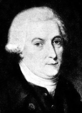
CAPTAIN GEORGE VANCOUVER, R.N., who explored the shores of Burrard Inlet in 1792. He was in command of H.M.S. Discovery, accompanied by H.M.S. Chatham, and sailed into the inlet on June 13. This inlet was named after Sir Harry Burrard of the British Navy.
The citizens fled before the wall of fire to the water-front, the wharves and the boats alongside. Those who did not run in the first five minutes were suffocated, and within forty minutes all that remained of Vancouver were a stone building in the west end, the Hastings Mill, one or two dwelling houses and eight or ten other structures on the banks of False Creek. Within four days of the fire new buildings were being erected in all parts of the city.
The Canadian Pacific Railway was completed and the first passenger train from Montreal arrived in Vancouver on May 23, 1887. Docks for ocean-going ships were built later, and Moodyville was incorporated as the district of North Vancouver. The arrival of the famous Canadian Pacific ships, the Empress of India, the Empress of China and the Empress of Japan, did much to develop the trans-Pacific service which conferred upon Vancouver its first prominence as a seaport.
The harbour is divided into several sections. The outer harbour is called English Bay. The central section of the harbour is entered through the First Narrows, soon to be spanned by a lofty suspension bridge. This entrance is called the Lions’ Gate because it is overlooked by two mountain peaks that resemble couchant lions. From this point to the Second Narrows lies the most important section of the harbour, about two and a quarter miles wide between the north and south shores and about five miles long. Across the Second Narrows is a bridge with a vertical lift span. Beyond, the harbour extends eastward for eight and a half miles to Port Moody, and the north arm of Burrard Inlet extends a further eleven and a half miles to the north. False Creek is spanned by bridges.
The Vancouver Harbour Commission, created in 1913, controls the port east of a line between Point Atkinson and Point Grey, at the entrance to English Bay.

The south shore of Burrard Inlet as it appeared in 1886. The sawmills had been established some years earlier, and around them had grown the villages of Hastings and Granville. Skyscrapers now rise from this site, and the photograph at the top of the page shows Granville as an important district of Vancouver in 1936.
Most of the docks and industries of the port are along the north and south shores of the central section of Burrard Inlet. The terminals combine dock, warehouse and distributing facilities. Piers and wharves of modern fire-proof construction provide ample transit shed room. The total shed area of the principal piers is 1,666,964 square feet. On the south shore, Pier B-C of the Canadian Pacific Railway, and Ballantyne Pier, owned by the Harbour Commissioners, are the two largest piers. They are equipped with the latest mechanical devices for handling goods.
There are seven grain elevators along the water-front, with nineteen grain-loading deep-sea berths. The elevators have a total storage capacity of 17,843,000 bushels, exclusive of domestic storage for 625,000 bushels, and they are equipped with cleaning, grading and drying facilities. At the Alberta Pool Elevator, mechanical car unloaders, by an ingenious arrangement of lifting devices, empty grain cars at the rate of twenty-one cars an hour.
The eight fish-oil tanks at Lapointe Pier are capable of storing 171,112 gallons. A new oil dock for handling vegetable, wood, nut and other oils, with seven storage tanks of 300,000 gallons capacity, is equipped with two electrically driven rotary pumps, either pump having a pumping capacity of 25,000 gallons an hour.
The Fish Dock, owned by the Harbour Commissioners, is one of the most modern on the Pacific Coast, and is equipped with smoke-houses, ice-making plant, freezing and holding rooms. The stalls are leased to firms engaged in the wholesaling of fresh and cured fish. The dock is equipped with six electric cranes. Two canneries are situated at the dock, and there is a mooring float 700 feet long.
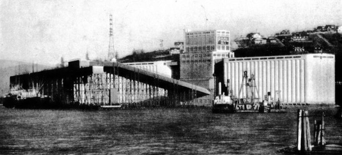
THE ALBERTA POOL GRAIN ELEVATOR has a capacity of 2,250,000 bushels. There are five loading berths adjacent to this elevator, and grain can be loaded at the rate of 75,000 bushels an hour. The export of grain is one of the most important activities of the port of Vancouver, and 96,872,722 bushels of wheat were exported in the year 1932-33.
Among the principal piers and wharves Ballantyne Pier, a reinforced concrete structure, has 2,610 lineal feet of berthing, with a depth at low water of 45 feet at outer and 32 feet at inner berths. Lapointe Pier, a concrete structure, has 2,500 lineal feet of berthing, and a depth at low water of 35 feet.
Four of the Canadian Pacific Railway piers each provide more than 1,430 lineal feet of berthing, and Pier B-C, the largest railway-owned pier, has 2,510 lineal feet of berthing and a depth of 35 feet at low water. Numerous other wharves serve the oil companies, the sugar refinery and other industries, and more wharves are available for tug boats, fishing vessels and other craft.
A harbour patrol service and a fire-boat are maintained. The fireboat Pluvius is kept ready for service at any point in the harbour. She is 94 feet long, with a beam of 17 ft. 4 in, and can throw four powerful streams of water to a height of 200 feet.
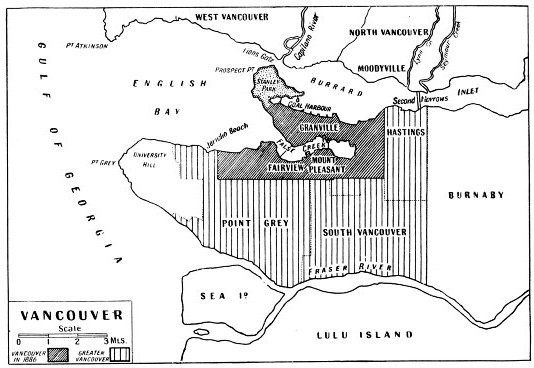
THE PORT OF VANCOUVER extends from Point Atkinson and Point Grey to the inland shores of Burrard Inlet, a distance of about twenty miles from the Lions’ Gate. The shaded portions of this map show how the town has developed in size from 1886. North Vancouver is mainly a residential district. The bridge across the Second Narrows was rebuilt in 1934, when a vertical lift-span replaced the original fixed span in the centre of the bridge. Plans for a bridge over the First Narrows have been approved by the Dominion Government.
Dry docks and repair yards are available, and there are various shipbuilding yards. The Burrard Drydock Company of North Vancouver has two building berths for ships up to 10,000 tons. This yard includes a great floating dock of 20,000 tons capacity. It is 556 ft. 6 in. in length and 98 feet wide between wing walls. The main pier is 700 feet long and the auxiliary pier 450 feet long. The equipment includes a 100-tons stationary crane. The Pacific Salvage Company’s yard contains a floating drydock of 800 tons capacity, three floating derricks and a number of salvage tugs. The West Coast Salvage and Contracting Company has derricks, pumps, diving and other salvage equipment.
The port of Vancouver is well equipped for supplying fuel oil, diesel oil and petroleum. Lighters are maintained by the companies at suitable places not served by pipe-lines. The Imperial Oil refinery at loco, on the north shore of the inmost reach of Burrard Inlet, has storage tanks of 1,272,500 barrels capacity, and a daily capacity of 17,000 barrels. The Shell Oil Company of British Columbia operates its western refinery on a 70-acres site on the south shore with a water frontage of 1,700 feet.
Timber Shipments
There is a marine service station barge in the gasoline marine service station area east of Stanley Park. In addition to the pipe-lines on the Union Oil Dock in Coal Harbour, pipe-lines are laid from both the Bonded Oil and Duty Paid Tanks to the Canadian Pacific Railway docks, and four vessels can load simultaneously.
There are three freight-car ferry services from Vancouver. They are run by the Canadian Pacific Railway and the Great Northern Railway to points on Burrard Inlet and Vancouver Island, and by the Pacific Great Eastern Railway from the Canadian Pacific ferry slip to the Pacific Great Eastern terminus at Squamish, along the coast north of Vancouver. One of the main activities of the port of Vancouver is the shipment of North American timber to all parts of the world. On the north shore of Burrard Inlet, west of Lynn Creek, is a lumber booming ground - as it is called - under the control of the Harbour Commissioners. Here the logs are released on order from the Harbour-Master. The workboat Brockton is available to assist in this work.
The Harbour Commissioners also maintain a signal station at Prospect Point. This station is manned by ex-naval ratings who report to the Harbour-Master’s office the approach of any incoming vessels.
Ships may enter Vancouver Harbour at any state of the tide. Land-locked and protected from the wind, the harbour is safe at all times even for the smallest craft. It is possible for vessels to load cargo in mid-stream. Despite its unrivalled natural facilities, however, Vancouver was for long handicapped by being so far from the European trade-routes.
The opening of the Panama Canal in 1915 gave Vancouver the opportunity of becoming a world port. Before this, the distance from Liverpool - round Cape Horn - had been 14,558 miles as against the 2,456 miles from Liverpool to Halifax on the Atlantic seaboard. The Panama Canal reduced the route from Liverpool to 8,547 miles. The importance to Vancouver of this reduction can be seen in the movements of Canadian wheat.
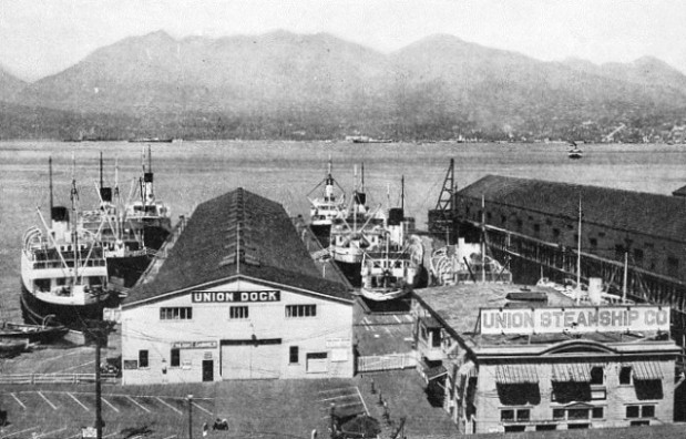
COASTWISE VESSELS of the Union Steamship Company at their piers on the south shore of Burrard Inlet, Vancouver Harbour. These ships penetrate every mountain-girt fjord for a distance of 400 miles along the coast of British Columbia. The fleet has developed from the original coastal vessels which plied on the shores of the Strait of Georgia. The Catala, the foremost ship on the left of the photograph, is typical of the modern fleet. She is a vessel of 1,476 tons gross and is driven by twin screws. Her length is 218 feet, her beam 37 feet, and her depth 18 ft. 5 in.
The first western shipment of grain for export from Vancouver was made in February 1909, when 8,000 bushels were loaded for Mexico. After the completion of the Panama Canal, a trial shipment of 99,209 bushels was made in 1917, and the first commercial cargoes, totalling 572,747 bushels, were taken in January 1921. Eleven years later, Vancouver, with an annual wheat shipment of 96,872,722 bushels, and a total annual grain shipment of 105,006,925 bushels, was in the forefront of the grain ports of America.
Eight ocean trade routes radiate from Vancouver: to Europe; to the Orient; to Australia, New Zealand, Hawaii, and Fiji; to the Atlantic coast of the United States and Canada; to Central and South America and the West Indies; to California; to South Africa; and to the coastal ports of America.
The port of Vancouver is regularly used by the steamship lines of the world. The Blue Funnel Line, The Blue Star, Canadian Pacific, Furness, Donaldson, Harrison and the Royal Mail are among the important British lines that use the port. Ships may be seen in the harbour flying the flags of the North German Lloyd, Nippon Yuesn Kaisha, Compagnie Generale Transatlantique, Navigazione Libera Triestina, Holland-America, Fred Olsen Line and others. The activities of the port also bring ships belonging to the Fruit Express Line, and Imperial Oil Ltd., and many American and coastal steamship lines.
The Empress of Japan, 26,032 tons gross, the flagship of the Pacific fleet of the Canadian Pacific Line and holder of the Blue Riband of the Pacific, is the largest liner using the port. Other representative vessels are the motor ship Amerika, 10,110 tons gross, of the Danish East Asiatic Line, on the European service; the N.Y.K. Hikawa Maru, 11,622 tons gross, on the Orient route; the Wyoming, 8,062 tons gross, of the Compagnie Generale Transatlantique; and the Pacific Pioneer, a 6,723-tons Furness Line refrigerated ship that carries British Columbia fruits.
These ships, and all craft that enter Vancouver harbour, pass through the Lions’ Gate. Near this channel lies the wreck of the famous pioneer ship, the Beaver. Built for the Hudson’s Bay Company, the Beaver was launched at Blackwall, on the River Thames, in 1835. She was 101 feet long and was armed with five 9-pounder guns. She reached Astoria, on the Columbia River, in the following year, and was employed in conducting hydrographic surveys. She was sold in 1874. Fourteen years later she ran ashore near the Lions’ Gate, where she now lies.
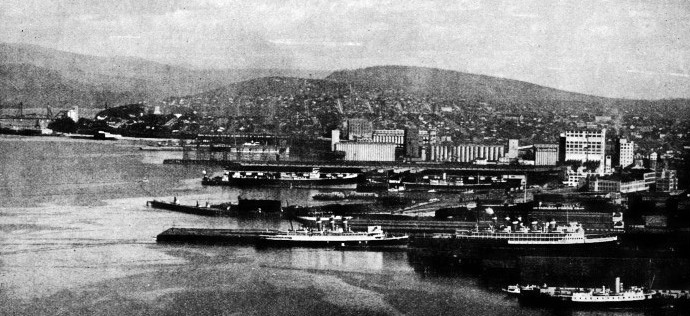
AT THE ENTRANCE OF THE SECOND NARROWS, on the Hastings shore, are the main piers for the coastal vessels sailing from Vancouver. In the foreground are the Canadian National and Union Steamship Companies’ piers. Huge grain elevators rise in the background, and on the left can be seen the lifting span of the Second Narrows Bridge.
Click here to see the photogravure supplement to this article.
You can read more on “Canada’s Prairie Port”, “The Great Lakes” and “Great Ports of the World” on this website.


 Late in 1884 Lachlan A. Hamilton, a youthful Canadian Pacific Railway surveyor, stood in a dense thicket, drove a stake into the ground and began to lay out a system of streets. A survey party under the direction of the civil engineer, John W. Stewart, took three days to cut a path, one mile long, through the forest. Within less than a lifetime Vancouver has grown from a settlement in a forest clearing into a thriving city. The city of Vancouver was incorporated by Act of Parliament on April 6, 1886. Some weeks later, shortly after midday on Sunday, June 13, a clearing fire at the far end of the 300 acres of fallen forest got out of control. Driven by a summer gale of such force that a barque in the vicinity was torn from her moorings, the fire raged through the mile length of massed wood, branches and leaves.


