

© Shipping Wonders of the World 2012-

Durban: South Africa’s Eastern Port
The harbour of Durban is formed by a natural lagoon, the only opening on a long stretch of the eastern coast of South Africa. A deserted wilderness just over a century ago, Durban now handles more cargo tonnage than any other South African port
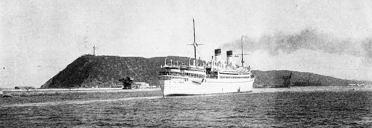
THE ENTRANCE TO DURBAN HARBOUR is a channel between the South Breakwater which extends from the Bluff, shown above, and the North Pier, which is built from a low spit of land known as the Point. This photograph shows the Italian quadruple-
DURBAN is a noteworthy example of man’s improvement upon nature, for the magnificent city and harbour have risen on a site which, little more than a century ago, was a wilderness. Durban handles more cargo tonnage than any other port in the Union of South Africa.
Ships of more than 25,000 tons and drawing more than 30 feet of water frequent a harbour once considered unsuitable for sailing vessels because of a dangerous bar at the entrance. This bar used to alter in shape and size after every storm. Engineering skill has conquered this obstruction and converted a once deserted lagoon into one of the main sea-
In the year ended March 31, 1935, the total tonnage of cargo and bunker coal handled was 4,333,575.
About 90,000 of the 225,000 inhabitants of Durban and its suburbs are Europeans, the remainder being natives, Indians and other coloured people. The port is in the Province of Natal. The name Natal was given to the coast by Vasco da Gama because he sighted the land on Christmas Day, 1497, during his voyage round the Cape of Good Hope to India.
The Portuguese did not land, and the growth of Durban is due to the enterprise of British seamen and traders. They called the harbour Port Natal, as the lagoon was the only opening for their ships on a long stretch of coast. The name of the modern city is derived from that of Sir Benjamin d’Urban, who was Governor of the Cape when the handful of settlers at Port Natal decided to form a town in 1835. At the centenary in 1935 the Borough of Durban became the City of Durban. The name Port Natal is still applied to the wharves on the shores of Durban Bay.
Situated on the east coast of South Africa, Durban is more than 800 miles by sea from Capetown, nearly 400 miles from Port Elizabeth and 253 miles from East London. The nearest port to the north-
The harbour of Durban is a landlocked lagoon comprising about seven and a half square miles of water. It is rather in the shape of a pear, with the narrow entrance for the stalk, and it is about three and a half miles long and two miles wide. The entrance is easily picked up from seaward by sighting the Bluff, a headland which forms the south eastern corner of the bay and juts out into the Indian Ocean. The bluff rises to a height of 195 feet, and on the summit is a lighthouse showing a light of three million candle-
At right-
The channel has been dredged to afford a depth of about 37 feet at low water ordinary spring tides. The extent of the work can be estimated by the fact that at one time there was only from 2 feet to 6 feet of water over the bar at low tide. As spring tides rise 6 feet and neap tides only 3½ feet, the old-
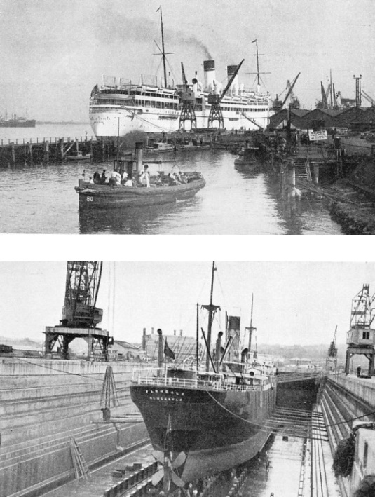
ONE OF THE LARGEST LINERS calling at Durban is the Italian quadruple-
THE PRINCE EDWARD GRAVING DOCK was the largest south of the Equator when opened in 1925 by King Edward VIII, then Prince of Wales. The length of the dock at the bottom is 1,150 feet and the width at entrance 110 feet. The dock is situated at Congella, in the south-
The two peninsulas of the Bluff and the Point form the seaward walls of a natural wet dock for ships from all parts of the world. To serve them, more than three miles of wharves and quays have been built with depths alongside ranging at low water from 23 feet to more than 38 ft. 6 in.
The services of shipping companies of many maritime nations include calls at the port of Durban. The Blue Funnel Line, the Clan Line, the Hall Line and the Union Castle Line are among the many British lines that send cargo and passenger vessels to Durban. Ships of the Holland-
One of the largest vessels that uses the port is the Athlone Castle, 25,564 tons gross. The Clan Urquhart, 9,564 tons gross, and the Holland-
The main shipping activities are concentrated at the Point. Where the liner passenger lands there are quays with a total length of more than a mile. There are eleven sheds, a bonded store and an ample equipment of electric cranes. The most powerful of these has a lift of 80 tons.
Pre-
A feature of this part of the harbour is the grain elevator, which can store 42,000 tons and has an intake of 1,000 tons an hour and a similar output for loading ships at the wharf. The grain exported is maize, not wheat.
At the end of-
Ships which are too large for the floating dock are accommodated in the Prince Edward Graving Dock. The dock is divided into two compartments, either of which can be used independently.
The depth in the dock at high water ordinary spring tides is about 41 feet. Built of reinforced concrete; the dock was opened by King Edward VIII when he was Prince of Wales. Much land has been reclaimed from swamp in this part of the harbour and has been sold for industrial sites.
Oil tankers berth at the Island View Wharf on the Bluff and discharge into tanks. There are twenty-
The coaling berths are located on the Bluff near the entrance channel. The exports of coal have helped to make the port of Durban prosperous. The coal is shipped to East African and Red Sea ports, largely by Union Government vessels, as well as to other parts of the world. Durban is the premier port for coal exports in the Union of South Africa. Five ships may coal simultaneously, three at the bucket transporters and two at the belt conveyer. The capacity of the loading plant, exceeds 1,000 tons an hour. The length of quayage at the Bluff is 2,365 feet.
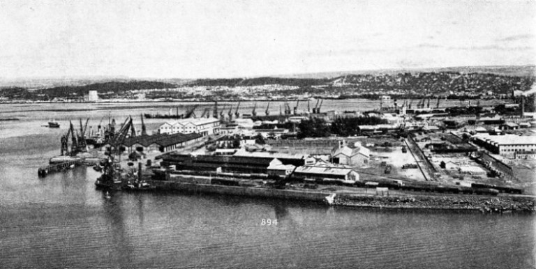
PASSENGER LINERS BERTH AT DURBAN at the mile-
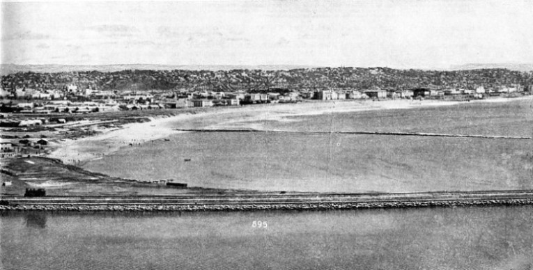
THE NORTHERN ENTRANCE TO THE HARBOUR OF DURBAN is bounded by the Point, which is shown in this photograph. A breakwater extending 2,350 feet from the Bluff marks the southern boundary of the harbour. The entrance (left) is 600 feet wide at its narrowest point and the harbour itself covers an area of more than seven square miles.
In addition there are bunkering facilities on the Point side of the harbour for ships loading or discharging cargo. The facilities for shipping coal and the proximity of the coalfields helped Durban to become the greatest port in the Union during the war of 1914-
Since 1910, when the Union of South Africa came into being, Durban and all other harbours have been controlled by the South African Railways and Harbours Administration. The port equipment at Durban includes five large tugs with salvage and fire-
Apart from its commercial importance Durban attracts thousands of visitors as a seaside resort. Frost and oppressive heat are unknown, the mean minimum temperature for the winter being 63° F., and the mean maximum for the summer 81°. The green headland of the Bluff shelters the harbour and the city from gales from the south-
The town hall and municipal buildings are in the centre of the city in West Street, which runs parallel with the Victoria Embankment facing the harbour, and is at right-
Afloat and ashore the scene is extraordinarily varied. In the harbour are crack liners which have paused in their ocean stride to pick up passengers, mails and freight. There are tramps, tankers, colliers loading at the Bluff and whalers from the rim of the Antarctic ice. Ashore are Zulu rickshaw boys arrayed in barbaric splendour, statuesque Zulu women, Indians, Chinese and smartly dressed European women.
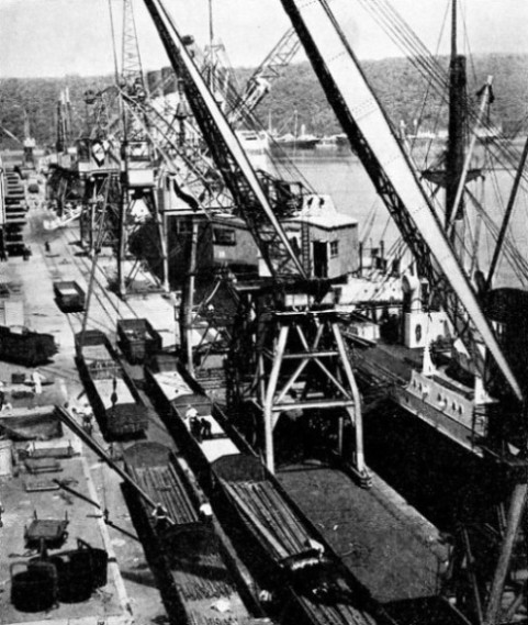
THE MAIN SHIPPING ACTIVITIES at Durban take place along the quays on the Point. The quays have a total length of 6,266 feet with a depth of water alongside varying from 23 feet to 38 ft. 6 in. They are amply equipped with modern fixed and moving electric cranes as well as with four 10-
South Africans, even those who live hundreds of miles inland, are noted for their love of the sea and ships, and Durban provides sea interests to appeal to all, whether they are swimmers, fishermen, yachtsmen or lovers of big ships. The sea angler can graduate from fishing in the bay to rock fishing outside it and trying his skill against kingfish, barracouda and sharks, although a tussle with a 700 lb. shark is not a sport for the inexperienced. The bay is noted for the enthusiasm of its yachtsmen. Some have tried their helmsmanship in the Solent, where, however, they found that the swift tides and the difference in the power of the wind caused by the greater humidity of the English climate handicapped them against British yachtsmen.
Enriched as South Africa is by Nature in mineral resources, the Union lacks the advantage of deep natural harbours, and this drawback has been surmounted in recent years only by a progressive policy of harbour construction. Except for the steady work of the engineers who conquered the natural disadvantages of the bar Durban would not have emerged from the wilderness.
The story of the port is the romance of men of the sea determined to make a safe harbour for their ships on a coast that had for centuries been a terror to all mariners. Ships homeward bound from India, the East Indies and China foundered on the desolate coast; and those passengers and sailors who were not drowned in the surf mostly perished from starvation or, as they walked along the coast in the hope of reaching the Portuguese settlement at Lourenco Marques, were killed by the natives. For centuries after da Gama had sighted Natal none except shipwrecked Europeans landed.
The natives inhabiting the shores of Durban Harbour were less aggressive than those elsewhere. In the seventeenth century the survivors of three wrecked ships, the Good Hope, which had sailed from Gravesend, the Bonaventura of Bristol and the Stavinesse, a Dutch East Indiaman, combined to build a two-
Durban, or Port Natal as it was then, continued to have a shifting population of stranded mariners. One Dutch skipper bought the entire port for beads, copper and ironmongery, but lost his ship and the deed of purchase in a wreck. One of the survivors of this wreck became a captain and took his vessel into the harbour; she rolled so violently in the surf on the bar that he was injured by the swinging of the tiller. Inside the bay he found the sole survivor of three English sailors, who was. contented with his lot ashore although his two shipmates had been killed by the natives. He was joined by two men from a Dutch ship which had sailed without them. The brig Salisbury really began the story of the port. She was blown over the bar by a gale, and her name is commemorated to-
The first to arrive had as supercargo Henry Francis Fynn, an Irishman with considerable gifts of diplomacy. The bay and the country surrounding it had been conquered by a remarkable native named Chaka, who had transformed the Zulu tribesmen into formidable warriors and become an African Napoleon. By the time Farewell had arrived, Fynn had succeeded in gaining the friendship of Chaka, and this was turned to gratitude when Fynn healed Chaka of a wound that had been inflicted by a would-
An African Napoleon
Chaka was so grateful that in 1824 he made his mark on a document giving Port Natal and an area of several thousand square miles to the white men. King heard of the success of his former partner and sailed for Port Natal, but he was wrecked just north of the entrance. Chaka gave him land. This aroused the jealousy of Farewell, who refused to visit King when he lay dying in 1828.
No story of the founding of a great modern port is stranger than that of this handful of mariners dealing with a savage king who did not give a thought to massacring thousands of his subjects and was delighted with the white men’s presents of pills, ointments and hair-
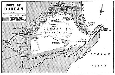
EXTENSIONS TO THE PORT OF DURBAN were proposed in 1936, as shown on this map. The proposed extensions comprise the reclamation of land between Congella and the Bluff, the dredging of deep-
The new township suffered many hardships. One Zulu raid reduced its British population to about a dozen.
Some years later the Boers, who had trekked overland from the Cape to found Natal, overthrew Dingaan and occupied Durban, from which a small British force had been withdrawn. The British sent a small force to reoccupy the settlement. The Boers took up a position at Congella and inflicted such a repulse on the British that the latter were besieged.
They were saved by the heroism of one man, Dick King. With a native to accompany him, King was rowed across the bay to the Bluff, two horses being towed behind the boat. King rode 600 miles to Grahamstown in ten days with news of the plight of the British. A relief force was sent by sea and Natal was annexed. Dick King, who made the greatest ride in South African history, is the subject of a statue in Durban.
The coast of Natal is so deficient in harbours that the possibility of using the lagoon at Durban as a harbour was often considered. Early opinions, however, were sceptical. When the East India Company contemplated taking possession of Natal they rejected the idea because it was said of the site of Durban “there is a reef or a sand bank at the mouth of the port that no galiot (merchant vessel) without touching could get over without danger, so that a small vessel could not safely go in there.” In 1824 a report stated that vessels up to 9 feet in draught could enter the lagoon at all times and “be as safe as in a wet dock”.
The early and rather discouraging reports are interesting to read in the twentieth century, for Durban is now the premier port of the eastern seaboard of South Africa. In fewer than a hundred years a great and important harbour has come into being. When the trade of Natal began to grow the need for improving the harbour was pressing. The bar presented a difficult problem that was not overcome for years. A beginning was the building of a pier from the Point in the hope of diverting the ebb tide to scour a channel over the bar.
This work was partly successful, and more schemes were discussed, but were shelved when it was reported that owing to rock the channel could not be made deeper than 18 feet. Then the discovery of gold and diamonds inland increased the value of the port and new attempts were made to conquer the bar. Fresh surveys showed that the rock was not continuous but consisted of boulders, which were removed.
Durban’s first steam tug, put into service in 1859, towed sailing ships into and out of the harbour. The following year a railway, the first to be built in South Africa, was built from the Point to the town. By the beginning of the century the depth of the entrance channel was 20 feet and since then this depth has been nearly doubled. The vessel with the deepest draught to leave the port was the Pelagos, 12,067 tons gross. She left the harbour in March 1930, drawing 36 ft. 8 in. of water.
Thanks to the development of the port, the industrial district of Congella has grown rapidly and Durban has become a great manufacturing and business centre, most of the factories in Natal being either in or near Durban.
A network of railways serves the docks at Durban and links them with the main South African railway system. Thus there is direct communication with all inland industrial centres for cargo discharged at Durban. Goods can be loaded directly into the railway wagons alongside by the ships’ slings.
Durban is the nearest port in the Union of South Africa to towns in Rhodesia, the Transvaal or the Orange Free State, and the journey to Bulawayo, Rhodesia, a distance of nearly 1,170 miles, is made in just over sixty hours.
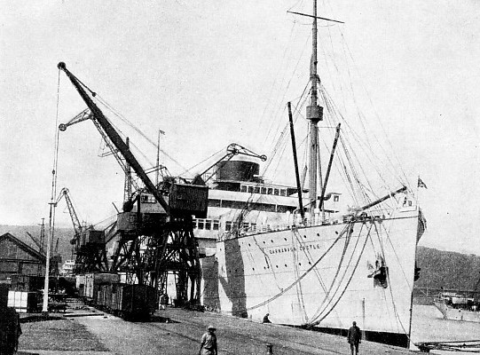
ALONGSIDE THE QUAYS AT THE POINT in Durban Harbour. This photograph shows the Union Castle liner Carnarvon Castle, a twin-
You can read more on “Fruit Carrying Ships”, “The Stirling Castle” and
“The Voyages of Vasco da Gama” on this website.